What's going on in Santorini?
An earthquake swarm has been observed north-east of the Cycladic island of Santorini since 27 January 2025.
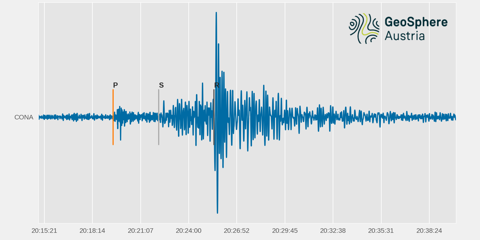
Several thousand seismic crustal events with depths of less than 20 kilometres have been recorded since then. The magnitudes of 215 of these events were between 4.0 and 5.0, ten events were stronger. The strongest event in the series occurred on 4 February at 02:46:07 UTC, with a magnitude of 5.3. Two further events with magnitudes greater than 5.0 were recorded on 8 and 12 February. These events were so strong that they caused several small rockfalls on Santorini. At that time, the population felt the shaking of the quakes almost every minute and is worried and frightened due to the possible danger of a tsunami in the event of an even stronger quake or a volcanic eruption. Many of these quakes were also measured by the Austrian Seismological Service at the CONA station at the Conrad Observatory. The station is around 1450 km away from the epicentre. The first earthquake wave takes 3.2 minutes to reach Austria. About 6 minutes later, the surface waves triggered by the quake also arrive. During the quake on 4 February 2025, the measuring station was raised by 0.02 mm.
Quake follows quake and memories of the severe earthquake of 1956 come flooding back. Schools were closed and both tourists and locals fled the island in a hurry.
waveform_Santorini 10-02-2025 Mw 5.2.png
Seismogram of the Santorini earthquake of 4 February 2025 recorded at the CONA station of the Austrian Seismological Service. It shows a 13-minute long section. The fastest earthquake wave (compression wave - P) took around 3 minutes to reach Austria. © GeoSphere Austria.
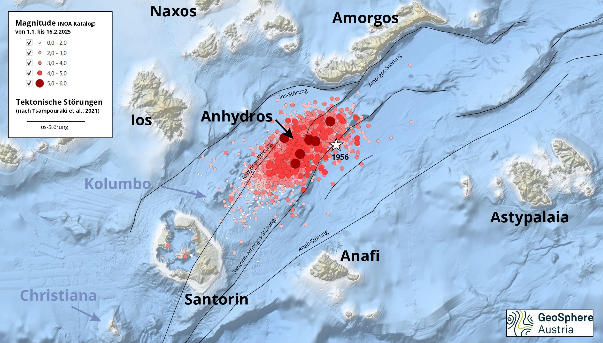
The earthquakes were localised in a zone in which a highly complex stress regime prevails. The Santorini - Amorgos zone is located in the centre of the Hellenic Volcanic Arc. The volcanic arc is a consequence of the subduction of the African plate under the Aegean plate. This causes the African plate to slide under the Aegean plate at a speed of around 1 cm per year and the front edge of the Aegean plate is lifted. The sinking of the African plate pulls the Aegean plate southwards and stretches it, technically known as extension, resulting in the formation of a stretched basin with a thinned crust. In the area of Santorini, there are north-east-south-west orientated faults, between which large-scale trenches are formed. These processes are accompanied by frequent earthquakes. Moderate to strong earthquakes have been measured in the Santorini-Amorgos zone since 1911. The strongest event with a magnitude of around 7.7 occurred on 9 July 1956, followed by another quake with a magnitude of 7.2. The quakes were accompanied by a tsunami with a height of 20 metres. These events were the strongest earthquakes in the southern Aegean in the 20th century. The current series of earthquakes has been taking place in this area since 27 January 2025. The great height of the tsunami in 1956 was probably caused by the additional local mass movements triggered by the earthquake tremors.
However, the formation of tectonically active fault zones is not the only consequence of subduction; a volcanic arc also forms at a distance of around 150 kilometres from the plate boundary. Here, the subducting African plate is melted at depth in the earth's mantle and the resulting magma rises and manifests itself in the volcanoes. One of these is Santorini. The island of Santorini is a remnant of a crater. The largest eruption of the Santorini volcano took place in the 17th century BC (Minoan eruption). Three eruption phases are known to have occurred in the 20th century, but these mainly produced lava flows. The last eruption was recorded in 1950. In 2011, an increase in microseismicity and an uplift of the caldera floor was observed, possibly due to magma movements from chamber to chamber within the volcano. This phase calmed down again in 2012. The Santorini volcano is part of a volcanic field that stretches from the Christiana Islands in the south-east to the underwater volcano in the north-east. The last eruption of the underwater volcano Kolumbo, which is located around 7 kilometres north-east of Santorini, was in 1650 and resulted in a tsunami that claimed 70 lives on Santorini. It is assumed that this volcano is not directly connected to the Santorini volcano, as the magma of the two volcanoes has a different geochemical composition.
santorin_2025_uebersicht2.jpg
Location of the epicentres between 27.1.2025 and 13.2.2025, tectonic fault zones are shown by red lines, the epicentres shown are taken from the NOAA earthquake catalogue (https://www.ngdc.noaa.gov/). © GeoSphere Austria.
Earthquake swarms are nothing unusual in the region, but they can still be precursors to stronger quakes. The intensity and strength of the quakes have increased since 27 January 2025. From 1 February, quakes with a magnitude of 4 occurred for the first time, and the strongest quakes with a magnitude of just over 5 occurred between 4 and 12 February. Even if the trend of a decrease in the strength and intensity of the swarm is currently apparent, the scenario of a temporary seismic calm, which could be followed by a strong quake, remains. The Austrian Seismological Service has so far recorded 225 quakes and linked them to the earthquake swarm.
Earthquake swarms can last a few months and then subside (swarm after the magnitude 7.4 quake in Taiwan, 3 April 2024), but stronger quakes can also follow (magnitude 7.5 quake, Noto, Japan, 1 January 2024) or a new fault surface could be activated. Seismic swarms in connection with active volcanoes often lead to uplifts that can be observed using GPS stations. In many cases, dormant phases then occur again. Should a volcanic eruption occur, this does not necessarily mean that it will be a catastrophic event.

gemessen_Wien_1302.png
Temporal distribution of the magnitudes of the epicentres of the large earthquake swarm northeast of Santorini registered at the measuring stations of the earthquake service in Austria (as of 13. 2. 2025). © GeoSphere Austria.
The events in the north-east of Santorini are either due to stress build-up and discharge along the fault zones or to volcanic activity, in which igneous rock and fluids rise upwards in the earth's crust. A combination of both processes is also conceivable: the earthquakes change the stress field in the crust and fluids can thus be moved into the crust or magma movements lead to stresses and activation of the fault zones. Possible scenarios include the generation of a tsunami. For this to occur, either a significant vertical displacement or another mass movement triggered by the earthquake must take place on the seabed. Localised tsunamis are also possible. A stronger seismic event could affect the activity of nearby volcanoes.
Due to various uncertainties, it is currently not possible for researchers to confirm any of these theories beyond doubt. It is likely that several processes are involved in the current events and that they influence each other. Seismic sensors have been installed on the seabed both by the National Observatory of Athens on the island of Anhydros and as part of the MULTI-MAREX project (https://www.marextreme.de/blog/categories/multimarex and https://www.geomar.de). There are also measuring devices in the caldera of Santorini. The epicentres have now been determined with a high degree of accuracy and the data is being analysed.
The situation is being reassessed daily. Please follow the instructions of the Greek authorities. It is recommended to avoid staying in harbours and an increased risk of landslides is warned. Non-structural weak points will be removed, water from swimming pools will be drained. The Greek authority sends warnings to mobile devices if the emergency notification is activated.
Earthquakes that occur at a great distance are also relevant for European institutions. As part of the EU multi-hazard project ARISTOTLE, the earthquake service as well as the weather service, together with other institutions from over ten countries, advise the Emergency Response Coordination Centre (ERCC) in Brussels. The ARISTOTLE project pursues a holistic and interdisciplinary approach to early warnings and assesses the impact of disasters (earthquakes, volcanic eruptions, tsunamis, floods, forest fires and extreme weather), which may require the mobilisation of international relief forces.
Seismological Service of Austria - GeoSphere Austria
Hohe Warte 38, A-1190 Vienna
Tel. +43 1 36026 2508
E-mail: seismo@zamg.ac.at
Translated with DeepL.com (free version)