The Phlegraean Fields - Information on the current situation
In the night of March 13th to 14th, 2025 Oder: In the early morning hours of March 14th 2025, a magnitude 4.6 earthquake occurred near the city of Naples in southern Italy. This earthquake is part of an ongoing swarm in the Phlegraean Fields and was the strongest that has been registered in the last 40 years.
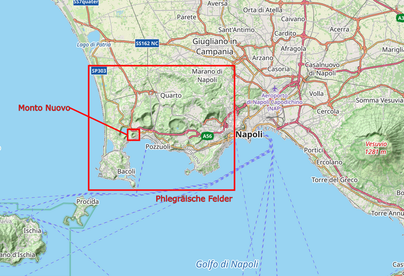
The Phlegraean Fields are a volcanically active area that has been active for over 80,000 years and extends over an area of 200 km², partly under water: from the coast west of Bacoli to the western border of Naples. As the name suggests (litterally translated ‘burning fields’), it is a volcanic field, i.e. a large cluster of volcanoes.
campi_flegrei_overview.png
Overview map of the Gulf of Naples with the Phlegraean Fields. Source: GeoSphere Austria/Rodler. Background map: © OpenStreetMap Contributors. Tiles courtesy of Tracestrack.
The caldera (a cauldron-shaped depression (hollow?) of volcanic origin) was formed over the course of at least two major volcanic eruptions: 40,000 and 15,000 years ago. In the last 5,500 years there have been a total of 27 eruptions, the last of which occurred in 1538.
The Phlegraean Fields are subject to a slow, recurring deformation known as ‘bradyseism’. This gradual uplift or subsidence of the caldera surface is caused by pressure changes in the underlying magma chamber. Throughout this process, mechanical tension builds up in the crust until it reaches a breaking point and an earthquake occurs. Since 2005, uplift of the Phlegrean Fields has been observed, with a maximum uplift of around 140 cm measured in the central area of the caldera, 500 meters south of Rione Terra (Pozzuoli).
There have been similar phases of ground uplift in the past, most recently from 1970–1972 (1.7 m uplift) and 1982–1984 (1.8 m uplift). In the second period in particular, the ground uplift was accompanied by increased seismicity, with a total of over 5,000 earthquakes being recorded. As in previous years, many earthquakes were observed within a very short period of time. - This is referred to as an earthquake swarm. The largest earthquakes during this so-called bradyseismic crisis were recorded on October 4, 1983 and March 14, 1984, both with a magnitude of M 4.0. At that time, there was severe damage to buildings in Pozzuli and a partial evacuation of the city took place.
Such earthquake swarms also occurred during the current bradyseismic crisis, with the strongest events on September 27, 2023 (M 4.2), October , 2023 (M 4.0), May 20, 2024 (M 4.4) and July 26, 2024 (M 4.0). Although the number and magnitude of earthquakes have increased in the last ten years, the majority of these earthquakes (around 97%) had magnitudes of ≤ 1.0.
Over the past three weeks, the average ground uplift rate in the largest deformation zone, near Terra Rione in Pozzuoli, has been around 30±5 mm/month (as reported in the Phlegraean Fields weekly bulletin from March 3-9, 2025).
The magnitude 4.6 earthquake that struck the region in the night of March 13 is the most energetic earthquake of the ongoing earthquake swarm so far. It caused the strongest ground acceleration in the last 40 years, also due to the very shallow focal depth of just 2 km. It was strongy felt by the population and caused some damage to buildings.
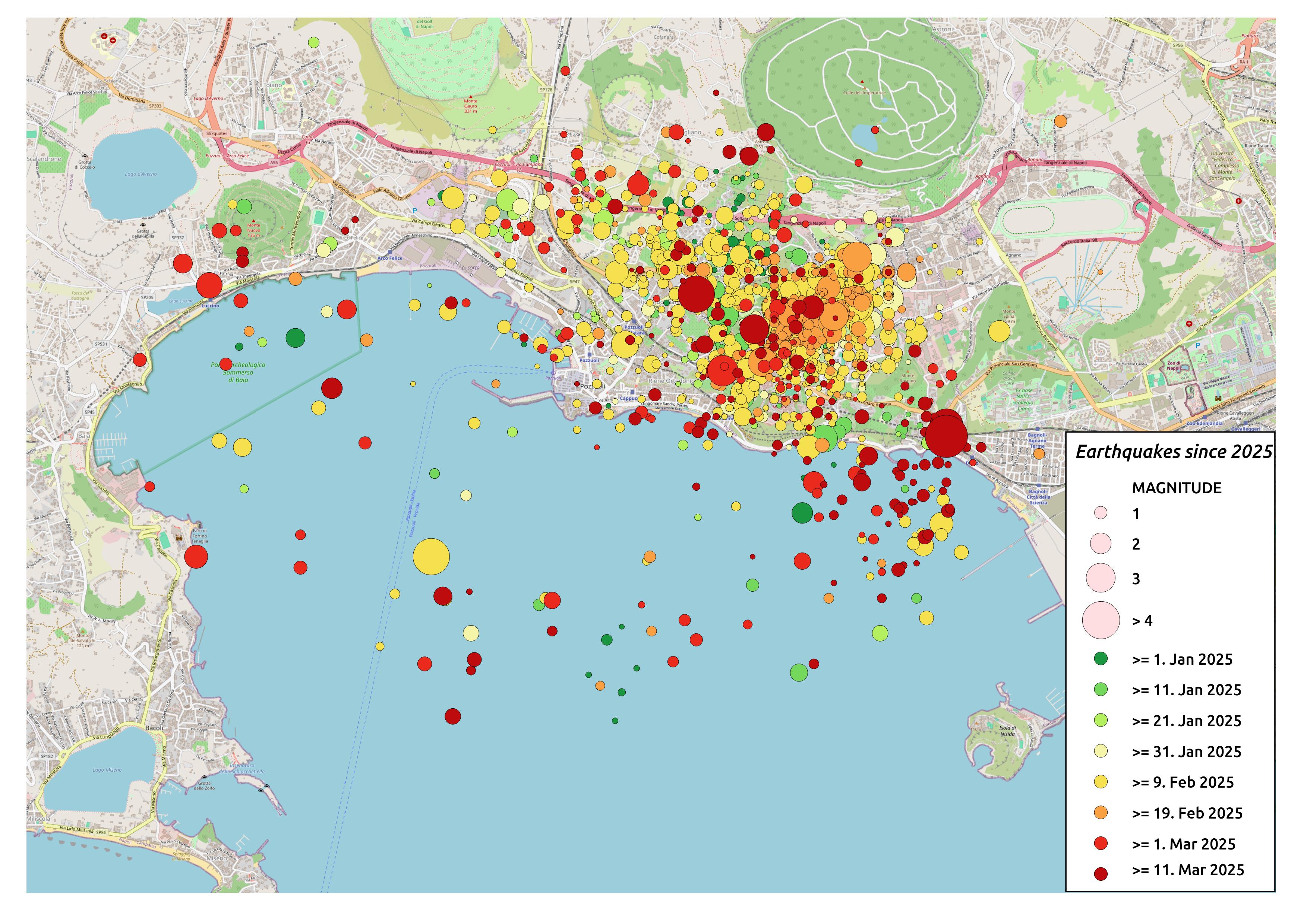
campi_flegrei_eventmap.jpg
Earthquake map of the Phlegraean Fields for the period from January 1, 2025 to March 17, 2025. The size of the circles corresponds to the earthquake. Source: GeoSphere Austria/Rodler. © Background map: OpenStreetMap contributors; event data from INGV.
According to the INGV, the earthquake on March 13 was part of a rapidly increasing ground uplift rate as deformation and seismicity in the Phlegraean Fields are closely linked. However, it is known from many years of observation of the region that there is no direct correlation between the rate of ground uplift and the magnitude of earthquakes.
The region is continuously monitored by scientists from the Vesuvius Observatory. Earthquakes in the region are measured and analyzed using a dense network of seismic stations, emissions from the volcano are monitored and GNSS stations provide precise values on deformation. At present (19.3.2025), according to the INGV, there is no evidence of an imminent volcanic eruption. There are currently no seismic processes being measured that indicate a movement of magma towards the surface, nor are there any geophysical and geochemical anomalies to indicate a disturbance of the hydrothermal system.
For further information on the current situation, please visit the websites of the regional civil protection as well as the italian earthquake service (INGV).