The wettest September in recorded history
At the beginning of September 2024, a heatwave that had lasted around two weeks in most of Austria and over four weeks in places in eastern Austria came to an end.
The beginning of September 2024 marked the end of a heatwave that had lasted around two weeks in most of Austria and over four weeks in some places in eastern Austria. "New maximum September temperatures were reached at many weather stations, such as in Andau, Eisenstadt, Gänserndorf, Langenlebarn, Hohenau an der March, Seibersdorf, Wiener Neustadt, Wien Innere Stadt and Fürstenfeld," says climatologist Alexander Orlik from GeoSphere Austria, at 35.9 degrees in Bad Deutsch-Altenburg on 3 September 2024, the Austrian record for a September was narrowly missed. It was 36.0 degrees, measured in Pottschach in Lower Austria on 1 September 2015.
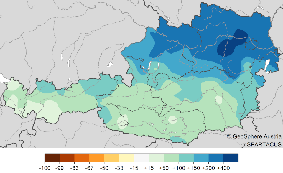
In the second week of September, there was a significant outbreak of cold air. This was accompanied by an area of low pressure that moved from Italy across Austria to Eastern Europe and brought very large amounts of rain, especially from 12 to 16 September. Most of Austria saw widespread rainfall of 100 to 200 millimetres, with parts of Lower Austria, Vienna and Upper Austria even receiving 250 to just over 400 millimetres in places. Flooding and mudslides were the result.
Niederschlag September 2024.png
Rainfall distribution in Austria for September 2024.
In the north and east of Austria in particular, it rained three to four times as much in five days as in an average September, and many weather stations set new September records for daily and multi-day precipitation.
The heavy rain in mid-September also set new September records for monthly precipitation at over 80 GeoSphere Austria weather stations. For example in St. Pölten and Langenlebarn (N) with 447 millimetres each. The previous September precipitation record was 202 millimetres in St. Pölten (1937) and 175 millimetres in Langenlebarn (2014).
There was also a new record in the Austria-wide evaluation. In September 2024, more than twice as much precipitation fell in Austria (+118 per cent) as in an average September. This is the highest value in the precipitation series since 1858 (before September 1899 with +111 per cent above average).
The onset of cold air with large amounts of precipitation also brought snow to many valleys. "In Styria, for example, there were 5 centimetres of snow at the Hall weather station near Admont, at 637 metres above sea level, on 13 September," says climatologist Orlik, "Snow below 1000 metres above sea level occurs on average every five years in Austria in September."
The amount of snow on the mountains was very unusual and set new records in some places. For example, at the Rudolfshütte in Salzburg (2320 metres above sea level) on 17 September 2024, the highest snow depth in a September since measurements began here in 1980 was 145 centimetres.
The unusual heat at the beginning of September, followed by a very cold middle of the month and an average end of the month result in an average to slightly above-average monthly mean temperature in the Austria-wide evaluation for September as a whole.
‘September 2024 was 0.7 degrees above the average for the 1991 to 2020 climate period in Austria's lowlands and 0.1 degrees below in the summit regions,’ says climatologist Alexander Orlik from GeoSphere Austria, ’which puts us in 43rd place in the series of the warmest September months in the 258-year measurement history in the lowlands and 80th place in the 174-year mountain measurement series in the mountains. On the mountains, this is the first month to be too cool since November 2023.’
Compared to the 1961-1990 climate period, September 2024 was 1.1 degrees above average in the lowlands and 0.1 degrees below average in the mountains.