New study on the spread of radioactive substances in cities
The Federal Office for Radiation Protection in Germany commissioned GeoSphere Austria to investigate, as part of the international research project EXPO-URB, how well different computer models can calculate the spread of radioactive substances in densely built-up urban areas. The results are compared with measurements taken in a wind tunnel using a detailed replica of a fictional city district. The GeoSphere Austria team is also working with its project partners to develop a new approach for verifying model calculations of the radiation distribution expected over the course of a year from industrial and medical releases. The results of the project were presented this week at an international scientific conference in Hamburg.
Very small amounts of radioactive substances can be released into the air from medical and industrial production via ventilation systems. The amounts are harmless to humans. As part of the approval process, authorities require calculations of radiation exposure to the population that are as realistic as possible for safety reasons. This calculation is particularly difficult in cities, as dense development significantly alters wind flow and turbulence.
In order to keep the calculation methods up to date with the latest scientific developments, Germany's Federal Office for Radiation Protection commissioned a research team from Germany (University of Hamburg, project management), Austria (GeoSphere Austria, Graz University of Technology) and Italy (ISAC-CNR) to carry out the EXPO-URB research project.
The Department of Environmental Meteorology at GeoSphere Austria has extensive experience in the development and operation of dispersion calculations of various scales, from urban areas to Europe-wide and global applications.
The aim of the EXPO-URB project is to investigate the suitability of Lagrangean particle models – such as LASAT, PALM, GRAL, MicroSwiftSpray and ARTM – for realistically estimating the spread of radioactive radiation in densely built-up urban areas. To date, the ARTM model used by the German Federal Office for Radiation Protection has been evaluated primarily for nuclear power plants located in open terrain, but not for urban scenarios with complex buildings.
‘Put simply, Lagrangian particle models are computer models that calculate the path of a large number of small air packets containing proportions of the released substance, depending on meteorological parameters such as wind and turbulence,’ explains Alexander Hieden, head of the CBRN accident modelling competence unit at GeoSphere Austria. ‘This allows us to estimate where the substances will spread, how much they will dilute and what concentrations will be present at specific locations, for example where people live or work.’
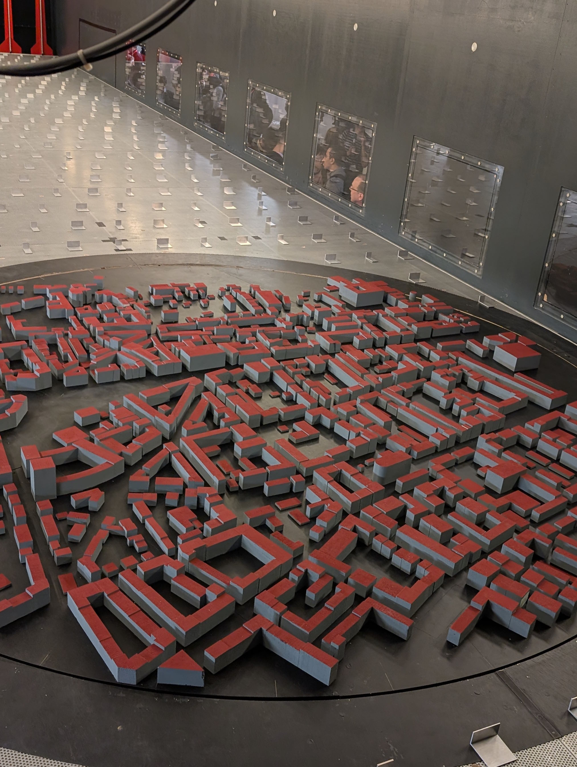
To test the quality of the models, the University of Hamburg carried out extensive measurements in a wind tunnel. A true-to-scale model of a city district was built for this purpose. During the wind tunnel experiments, a non-reactive gas was released at a point above the roof or on a building facade, and the flow and concentration were measured at many points within the city model. The influence of denser and looser construction and different roof shapes was investigated by changing the building models.
‘We compiled a validation data set from all measurements and investigations, which will be available for such applications in the future and shows the strengths and weaknesses of the individual models under different conditions,’ says Sirma Stenzel, expert in environmental meteorology at GeoSphere Austria.
Among other things, the investigations showed how much the results vary depending on the input data and level of detail. For example, the representation of buildings and assumptions about the emission release rate have a significant influence on the results.
The investigations also showed the relationship between the level of detail and the computational effort required for the individual models and how practical they are as a result.
The decisive factor for this application of dispersion models to monitor (non-accident-related) releases from production facilities in urban areas is the distribution of radioactive substances that occurs over the course of a climatologically average year. To this end, GeoSphere Austria calculated annual distributions based on meteorological measurement series from two cities located in very different locations, namely Munich and Dresden.
The EXPO-URB research project will run until March 2026. This week, the results of the studies completed to date were presented at the 23rd International Conference on Harmonisation within Atmospheric Dispersion Modelling for Regulatory Purposes in Hamburg.

Spread_Radioactivity_Project_EXPO-URB.png
Calculated spread of radioactivity using one of the models investigated in the EXPO-URB project. The graph shows the spread simulation of a continuous release of radioactivity over a whole year in a fictional urban environment. The data refers to the soil layer, which is intended to represent pedestrian level. As expected, the concentration is highest near the source and decreases with increasing distance. © GeoSphere Austria.
Model_wind_tunnel_project_EXPO-URB.jpg
Model in the wind tunnel: To test the quality of the models, the University of Hamburg carried out extensive measurements in the wind tunnel. © GeoSphere Austria/Hieden.
Translated with DeepL.com (free version)