Magnitude 7.7 earthquake in Myanmar
On Friday, March 28th, 2025, the Sagaing region in Myanmar (Burma) was shaken by a severe earthquake with a magnitude of 7.7.
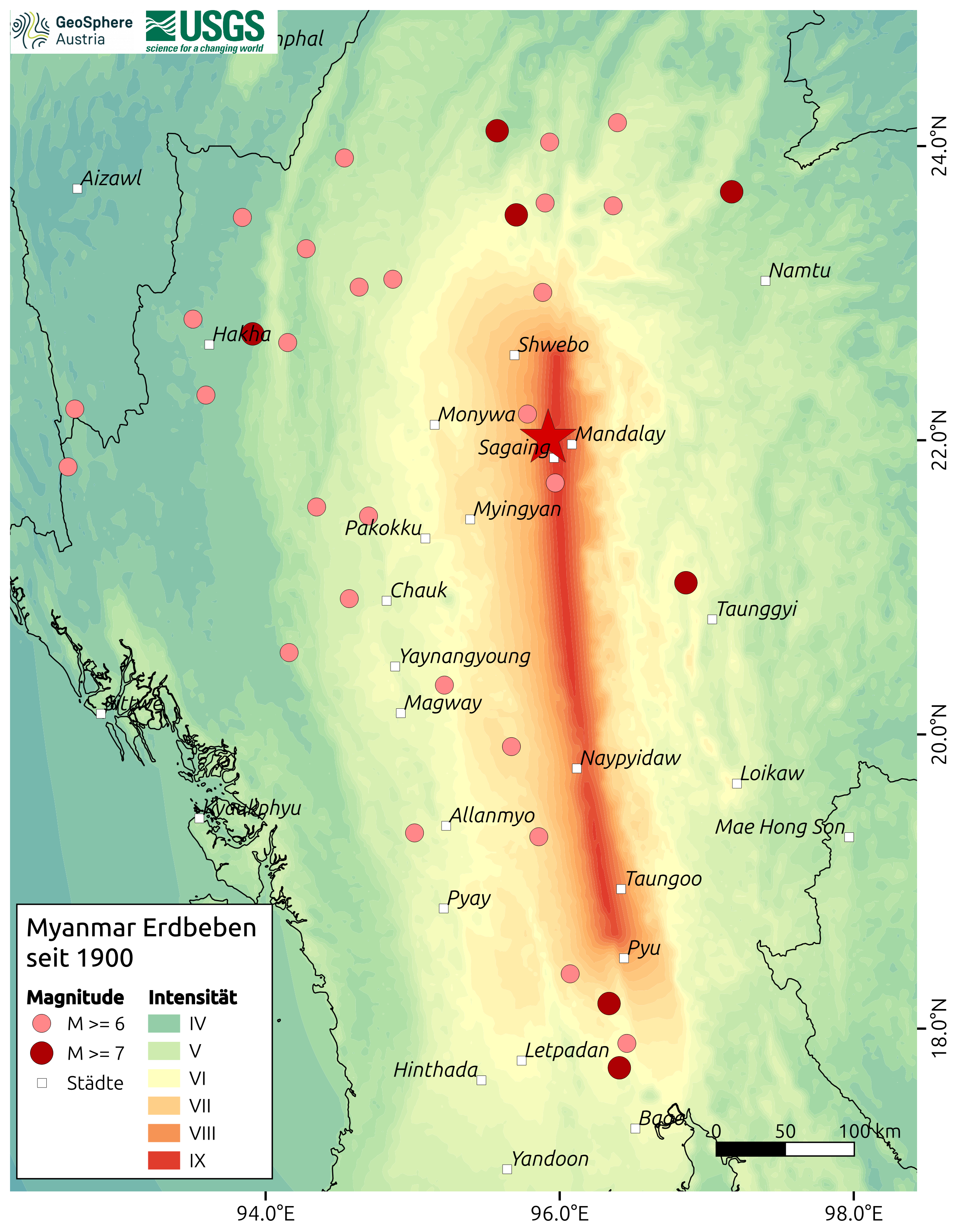
According to the US Geological Survey, the epicenter of the earthquake is located about 17 km southeast of the two cities of Mandalay (~ 1.2 M inhabitants) and Sagaing (~ 79 K inhabitants).
The tremors were felt up to a distance of 2,000 km, also in the neighboring countries of Thailand, India and China. The earthquake service of GeoSphere Austria routinely informs the media and government crisis management about the expected effects of earthquakes. In this particular case, both relevant aid organizations (Red Cross, AFDRU) and the Ministry of Foreign Affairs were informed.
As the earthquake caused power, telephone and internet outages in large parts of Myanmar, there was little information about the situation in the epicentral area in the first few hours after the quake. Information on the actual extent of the damage in the region could only be provided after the arrival of aid organizations. Overall, the population in this region lives in buildings made of wood or unreinforced brickwork, which are quite vulnerable to earthquake damage. Along with the communications breakdown, major roads were damaged, including a highway leading to Mandalay. There are unconfirmed reports on social media that the control tower (ATC tower) at the airport in the capital Naypyidaw has collapsed and flights have been diverted to Yangon.
Soil liquefaction caused ground instabilities in widespread areas. These are documented in many pictures as large cracks, water leaks or small mud-volcano-like structures. The phenomenon of soil liquefaction occurs when vibrations lead to the solidification of water-saturated, soil layers (often sandy or silty soils). Such loose soils have a high proportion of pores (cavities), where the rock particles touch at just a few points. These pores are typically filled with water or air. The compression wave of an earthquake increases the pore pressure in the water-saturated soil. This can cause the static friction between the sand grains to decrease, reducing the shear strength of the soil to such an extent that it behaves like a liquid. As a result, buildings on the surface can sink partway, leading to severe damage.
The epicenter of the M 7.7 earthquake on March 28th, 2025 is located on the Sagaing fault, an approximately 1,200 km long fault line between the Indian and Eurasian tectonic plates. It is one of the most important tectonic fault zones in Southeast Asia and has repeatedly led to considerable seismic activity in the past.
The Sagaing fault, which runs from north to south, separates the Burmese microplate in the west from the Sunda plate in the east. The fault machanism is a so called strike-slip fault, where the two tectonic plates move horizontally past each other at a rate of about 18 mm per year. According to Brian Baptie, a seismologist with the British Geological Survey, the quake shifted the earth's surface by five meters within a minute in some areas.
- On March 23rd, 1839, a strong earthquake south of Mandalay led to the destruction of the royal cities of Amapoora and Ava (Innwa).
- On May 23rd, 1912, an earthquake with a magnitude of 7.9 occurred south of Sagaing, near Taunggyi.
- In the span of just a few months, on May 5th, 1930 and December 3rd, 1930, two earthquakes with a magnitude of 7.3 each occurred in the Pegu (Bogi) and Pyu areas.
- North of Sagaing, earthquakes with magnitudes of 7.8 and 7.0 were documented on September 12th, 1946 and July 16th, 1956.
The Thai capital Bangkok, which is located more than 1,000 km from the epicenter, was also affected by the earthquake. The shaking caused one high-rise building to collapse mid-construction. Very strong earthquakes generate seismic waves with long oscillation periods that can propagate over long distances. This can cause high-rise buildings with long oscillation periods to sway considerably.
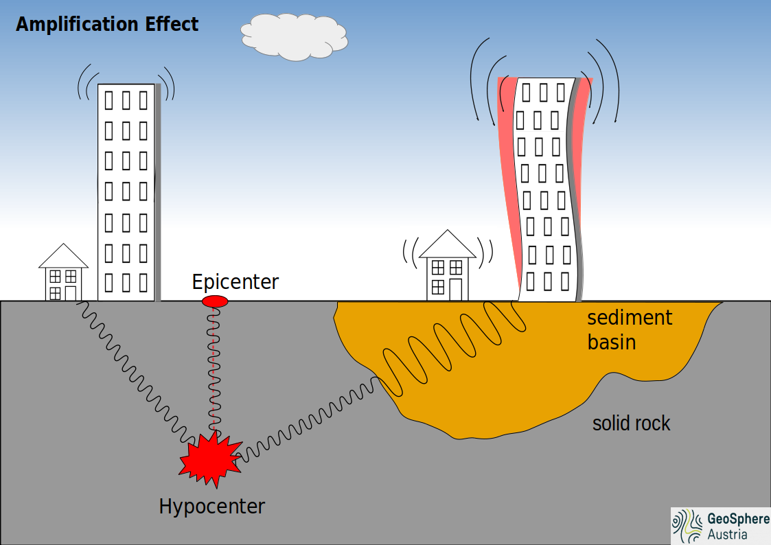
Although the metropolis is located far away from known active faults, the city's high-rise buildings have repeatedly been shaken unusually strong by past earthquakes in Myanmar or northern Thailand. The reason for this lies in the geological structure of the Bangkok Basin, which consists of deep alluvial sediments of the Chao Phraya River. Unlike the surrounding bedrock, this soft subsoil causes the seismic waves to be amplified, leading to stronger ground motion. Severe earthquake damage due to amplification effects in unfavorable ground conditions, such as soft subsoil, has also been documented in Mexico City.
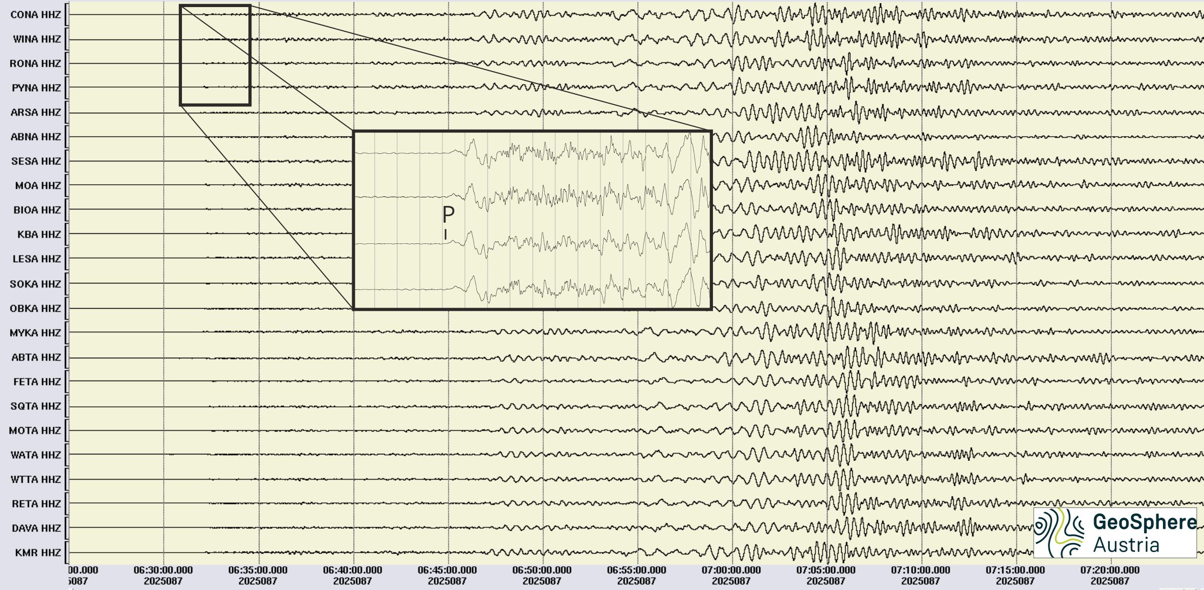
The following seismogram shows the registration of the earthquake in Myanmar at selected seismic measuring stations of the Austrian Seismological Service. The highly sensitive instruments can register worldwide earthquakes with a magnitude of about 5.0 and above. The signals from the magnitude 7.7 Myanmar earthquake are very clearly visible. The fastest earthquake wave (the compression wave or P-wave) took about 11 minutes to reach Austria.
With earthquakes of this magnitude, a large number of aftershocks can be expected over a long period of time (months to a year).
The strongest aftershock so far reached a magnitude of 6.5 and occurred only a few minutes after the mainshock of magnitude 7.7. Typically, the frequency and strength of earthquakes decreases over time. Nevertheless, further damage from aftershocks can still be expected during this phase - building structures that have already suffered damage from the main quake are particularly vulnerable. In very rare cases, a similarly strong or even stronger earthquake can occur.
Some earthquake experts place the location of the rupture zone of the current earthquake in a region where there has been a gap in documented earthquakes to date. This suggests that the earthquake has relieved a large part of the stress in this area. Calculations of the stress redistribution caused by this earthquake indicate that this has led to an increase in stress at both the northern and southern ends of the current rupture, with the southern part, near the capital Naypyidaw, being assumed to be at higher risk.


