
Magnitude 4.4 earthquake in the Gloggnitz/Semmering area
On Friday, 24 July 2026, at 01:59 CEST, a strong earthquake measuring 4.4 ML and with a depth of around 5 km occurred in the Gloggnitz/Semmering area of Lower Austria.
The Austrian Seismological Service has already received over 800 reports of the tremor being felt. The quake was felt across large parts of Lower Austria (as far as Krems), Styria (from Bruck an der Mur to the border with Slovenia), as well as in Vienna and Burgenland. We have also received isolated reports from Upper Austria.
From the area around the epicentre, where the tremors were strongest and many people were woken from their sleep, there are also initial reports of minor damage to buildings. The actual extent of the damage is currently being assessed.
According to initial analyses, the earthquake had a maximum intensity of VI on the EMS-98 scale.
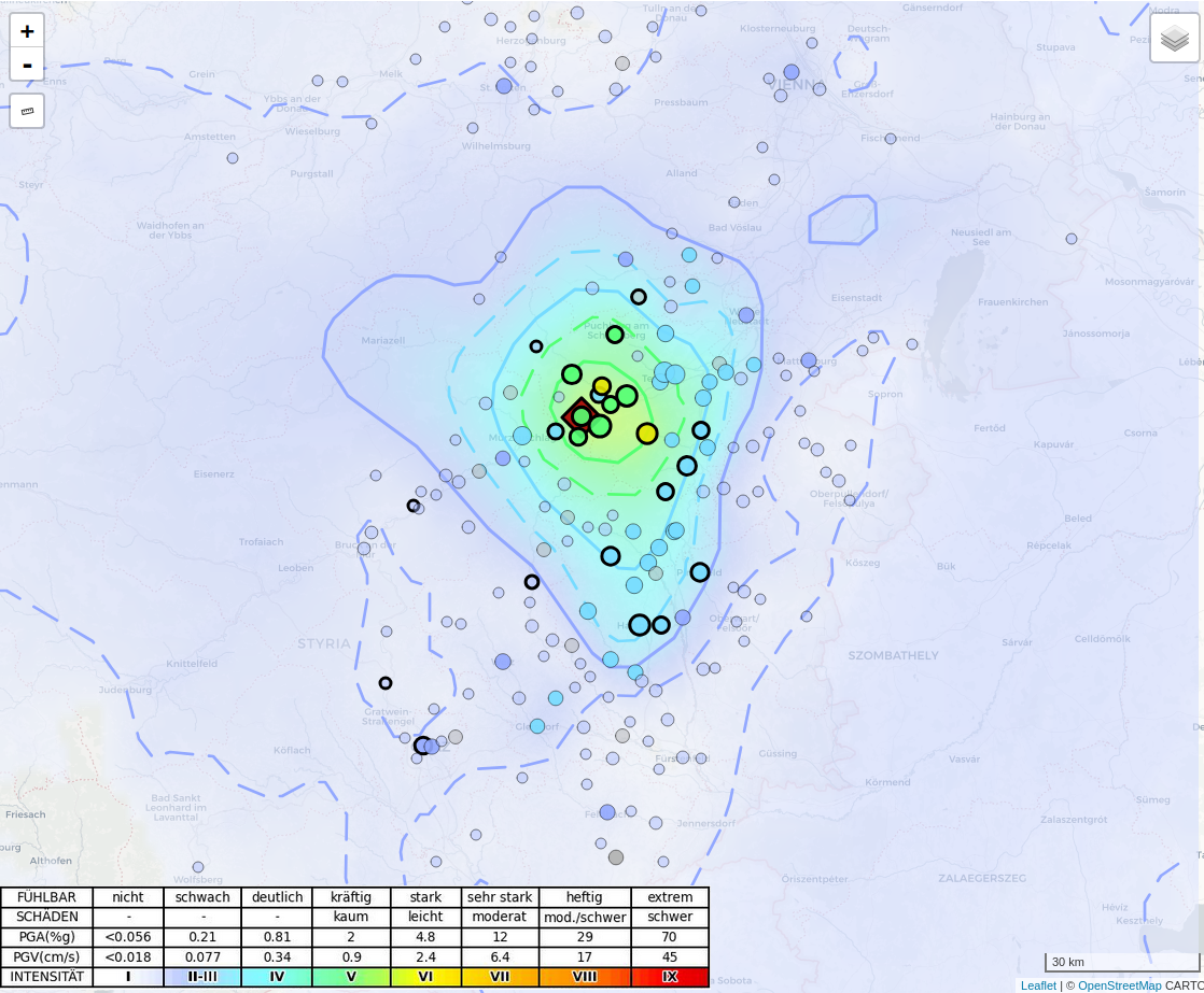
Eearthquake_Gloggnitz_Shakemap+reports.png
The map shows what is known as a ‘shakemap’. This depicts the area in which the earthquake may have been felt with a certain intensity. The dots represent the locations (grouped by postcode) from which reports have been received from the public. Circles with a bold border indicate that minor damage to buildings has also been reported in these areas. The map is continuously updated as new reports come in; manually processing the individual reports can sometimes take weeks. Please note that the map displayed here cannot be used as evidence for insurance purposes. © GeoSphere Austria.
On average, ten earthquakes are felt in Lower Austria each year. Approximately every eight years, earthquakes occur that cause minor damage to buildings. Stronger earthquakes, which occasionally cause more significant damage, occur every 30 to 40 years, whilst even stronger ones occur at intervals of more than 100 years.
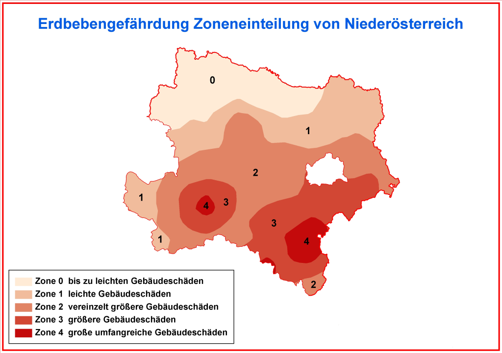
Earthquake_Gloggnitz_hazard-map.png
Earthquake hazard map for Lower Austria. © GeoSphere Austria.
The most recent earthquake in this category, which had an intensity of Grade VIII on the EMS-98 scale (severe damage to buildings) and a magnitude of 5.2, occurred on 8 October 1927 in Schwadorf.
Stronger earthquakes have also been recorded in the Semmering area, such as the 1964 earthquake (magnitude 5.3) and the 1984 earthquake near Maria Schutz (magnitude 4.9). The most recent significant earthquake in the region occurred on 1 February 2024 near Semmering, with a magnitude of 4.6. It reached a maximum intensity of VI on the EMS-98 scale and also caused minor damage to buildings.
What is believed to be the strongest earthquake in recorded history occurred on 15 September 1590 in Ried am Riederberg. It caused extensive damage in the Tullnerfeld and in what is now the federal capital (see Vienna).
The earthquake of 24 July 2026 was recorded at all broadband seismic stations of the Austrian Seismological Service. The figure shows the recordings of the vertical components of the seismometers over a 3-minute time interval. The seismogram shows the time in UTC (Coordinated Universal Time).
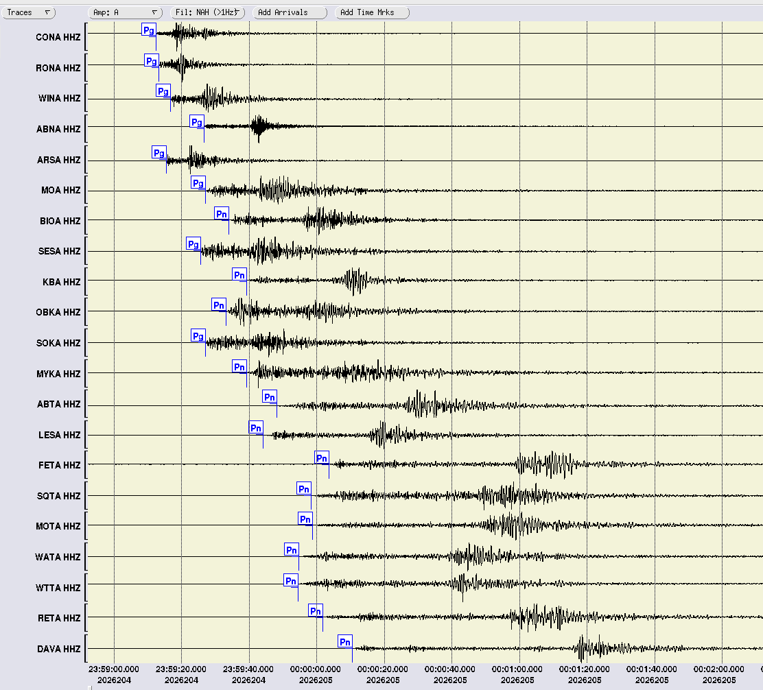
Earthquake_Gloggnitz_Seismogram.png
Seismogram of the Gloggnitz/Semmering earthquake on 24 July 2026. © GeoSphere Austria.
The recorded ground acceleration values are significantly below the design values specified in ÖNORM 1998-1. This standard sets out the rules for the earthquake-resistant design and construction of structures in accordance with EUROCODE 8. At most locations, the acceleration values are comparable to those recorded during the earthquake in 2024 (magnitude 4.5 ML). Initial analyses of the focal mechanism suggest a strike-slip fault.
The majority of these earthquakes can be attributed to a fault in the Earth’s crust beneath the Vienna Basin, which stretches from Seebenstein to Schwadorf and beyond into Slovakia. Wiener Neustadt (1712, 1768, 1841) and Ebreichsdorf (1938, 2000) lie along this fault line and are recurring epicentres of earthquakes. This horizontal displacement contributes to the expansion of the Vienna Basin, a process that continues to this day and also leads to subsidence that is geodetically verifiable. An exception is provided by the isolated earthquakes on the edge of the Tulln Basin, which can be explained by a wedge-shaped thrust of the Kalkalpen over the Bohemian Massif.
Earthquakes in Lower Austria occur at depths of between 5 and 11 km.
The Province of Lower Austria funded a long-term project to record historical earthquakes in Lower Austria and, together with the Federal Ministry of Economy, Family and Youth (BMWF), facilitated the establishment of the Conrad Geophysical Observatory near Muggendorf, where comprehensive seismic observations are carried out.
Translated with DeepL.com (free version)