
Climate report for June 2026: Despite a record-breaking heatwave, it was not the warmest June on record
GeoSphere Austria’s preliminary June summary: Fourteen days of heat, with temperatures reaching 40 degrees, and record June highs at 157 out of 277 monitoring stations, followed by severe storms – some of them intense – sweeping across Austria from the west. The second half of the month, in particular, is likely to be remembered for a long time to come. However, the first half meant that June 2026 was ‘only’ the fourth-warmest on record.
‘In the second half of the month, Austria experienced one of the most extreme heatwaves in the country’s recorded history. Comparable heatwaves had previously only occurred in July or August; however, new records were set for June,’ summarises climatologist Alexander Orlik from GeoSphere Austria. ‘Before the heatwave, however, temperatures – at least when compared with the 1991–2020 climate period – were close to the climate average, and from 10 to 12 June they were even significantly below it. As a result, despite the extremely high temperatures, June 2026 did not turn out to be the warmest June in Austria’s recorded history.’
Just one day before the heatwave began to sweep across western Austria on 17 June – and the first temperature in the 30s was recorded in Bregenz – residents in Zwettl in the Waldviertel, at 502 metres above sea level, woke up to a temperature of 3.1 degrees. The absolute lowest temperature in June was recorded on the Brunnenkogel in Tyrol (3,437 metres): minus 10.1 degrees on 11 June. By the end of the month, temperatures in the lowlands had climbed to 40.1 degrees.
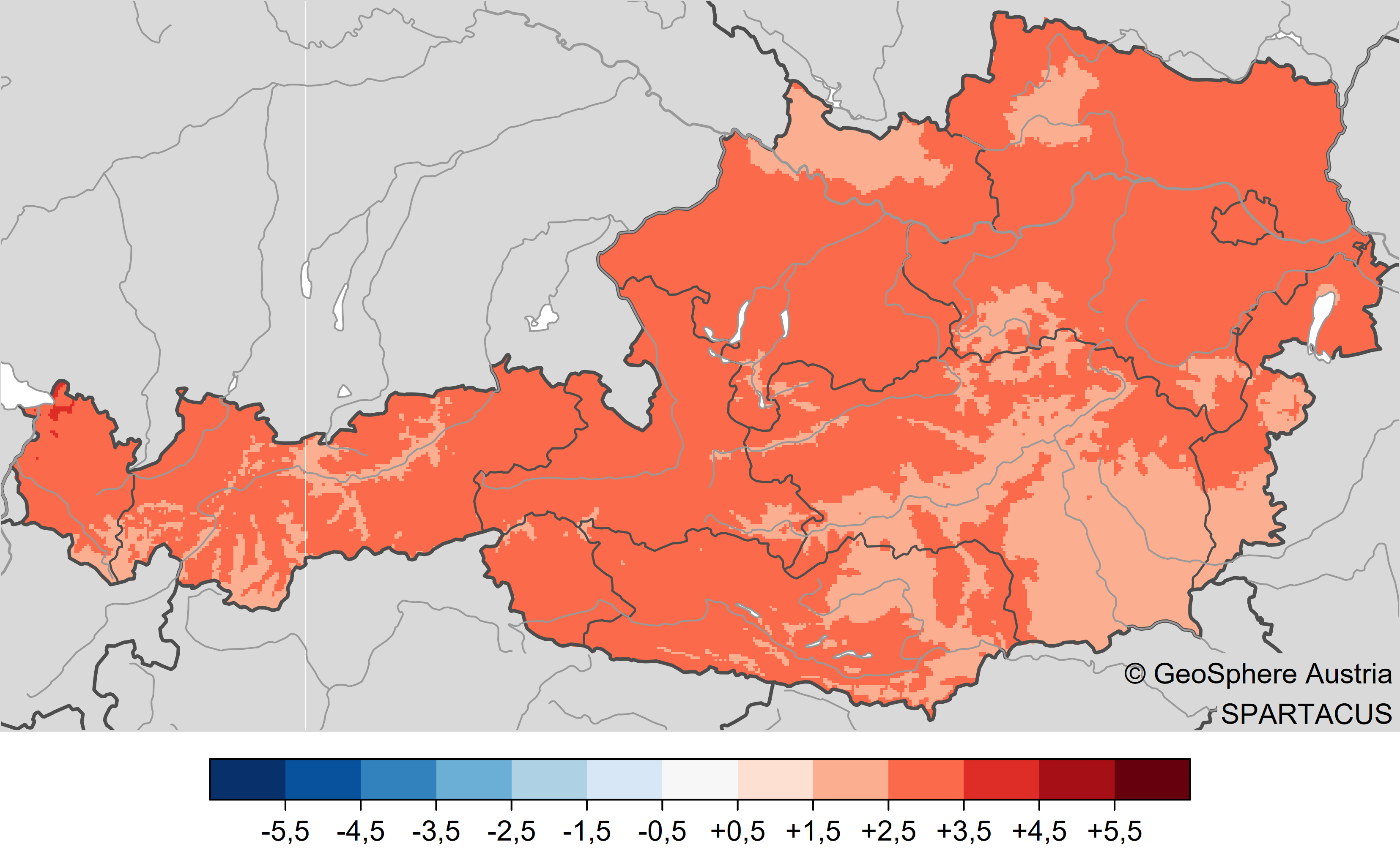
Temperatur im Juni 2026: Abweichung der Temperatur vom Mittel im Vergleich zum Mittel 1991-2020 (-> volle Auflösung). Auswertung mit SPARTACUS-Daten bis inkl. 30.06.2026. © GeoSphere Austria.
Temperature in June 2026: Deviation of the temperature from the 1991–2020 average (-> full resolution). Analysis based on SPARTACUS data up to and including 30 June 2026. © GeoSphere Austria.
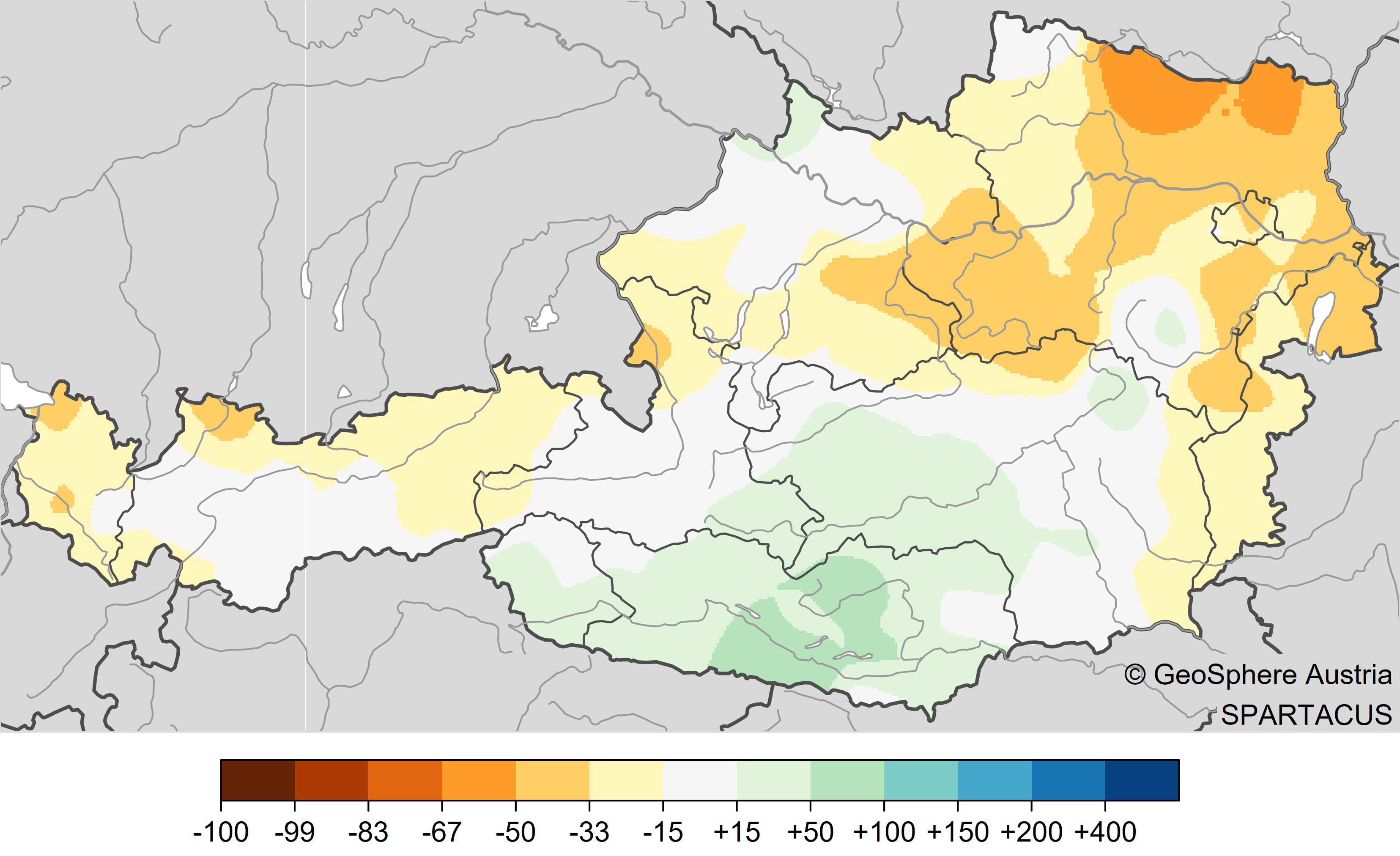
During the first two weeks of June, there were repeated showers across the whole of Austria, with snow also falling in the high mountains. During this period, there was a significant amount of rainfall, particularly in East Tyrol, Carinthia, the Lungau region and western Upper Styria. From the middle of the month, however, sunny high-pressure weather increasingly took hold. With the onset of the heatwave, there were only isolated showers and thunderstorms, some of which were very intense. For example, on 20 June, 97 millimetres of rain fell in Bruck an der Mur (ST) within two hours, and 93 millimetres fell in Puchberg am Schneeberg within two and a half hours. Generally, however, the period from 15 to 27 June remained largely free of rainfall. With strong sunshine and relatively low humidity, evaporation was correspondingly high. During the hot and dry second half of June, the drought – which had been persisting since December 2025 – worsened dramatically. Lower Austria, Vienna and northern Burgenland were particularly hard hit. However, from Vorarlberg to Upper Austria, there was also insufficient rainfall in June to provide the topsoil with adequate moisture.
juni_2026_Niederschlag_vgl_91-20-1.png
Precipitation in June 2026: Deviation of precipitation from the mean compared with the 1991–2020 mean. Analysis based on SPARTACUS data up to and including 30 June 2026. © GeoSphere Austria.
As things stand, the average picking maturity of sweet cherries in Austria occurred significantly earlier than the average for the years 1991 to 2020. The warm weather at the end of May, in particular, is likely to have accelerated the ripening of the cherries. The start of flowering in grapevines, on the other hand, was fairly close to the 1991–2020 average, with flowering beginning one day later than usual. The start of flowering in the small-leaved lime and the harvest maturity of redcurrants signalled the start of the phenological high summer in many places.
Translated with DeepL.com (free version)