Alpine climate: Winter half-year 2024/25 balance sheet
The German Weather Service, MeteoSwiss and GeoSphere Austria publish a joint evaluation of the current climate in the Alpine region and its classification in the long-term development twice a year. The report for the winter half-year 2024/25 has just been published.
The long-term trend for winter in the Alpine region shows a significant warming and strongly fluctuating amounts of precipitation from year to year. Snow at low and medium altitudes is becoming less and less, as precipitation increasingly falls as rain due to the higher temperatures.
The winter half-year 2024/25 confirmed these trends. The effects were intensified by the above-average number of high-pressure weather conditions and created additional special features. In addition, the dry weather over long periods meant that there was relatively little snow at high altitudes for the most part.
The winter half-year 2024/25 (November to April) was 1.6 degrees warmer in the Alpine region of Germany, Austria and Switzerland than the average for the period 1991 to 2020. The evaluation by altitude shows a deviation of +1.9 degrees from the climate average in the summit regions and +1.4 degrees in the lower altitudes.
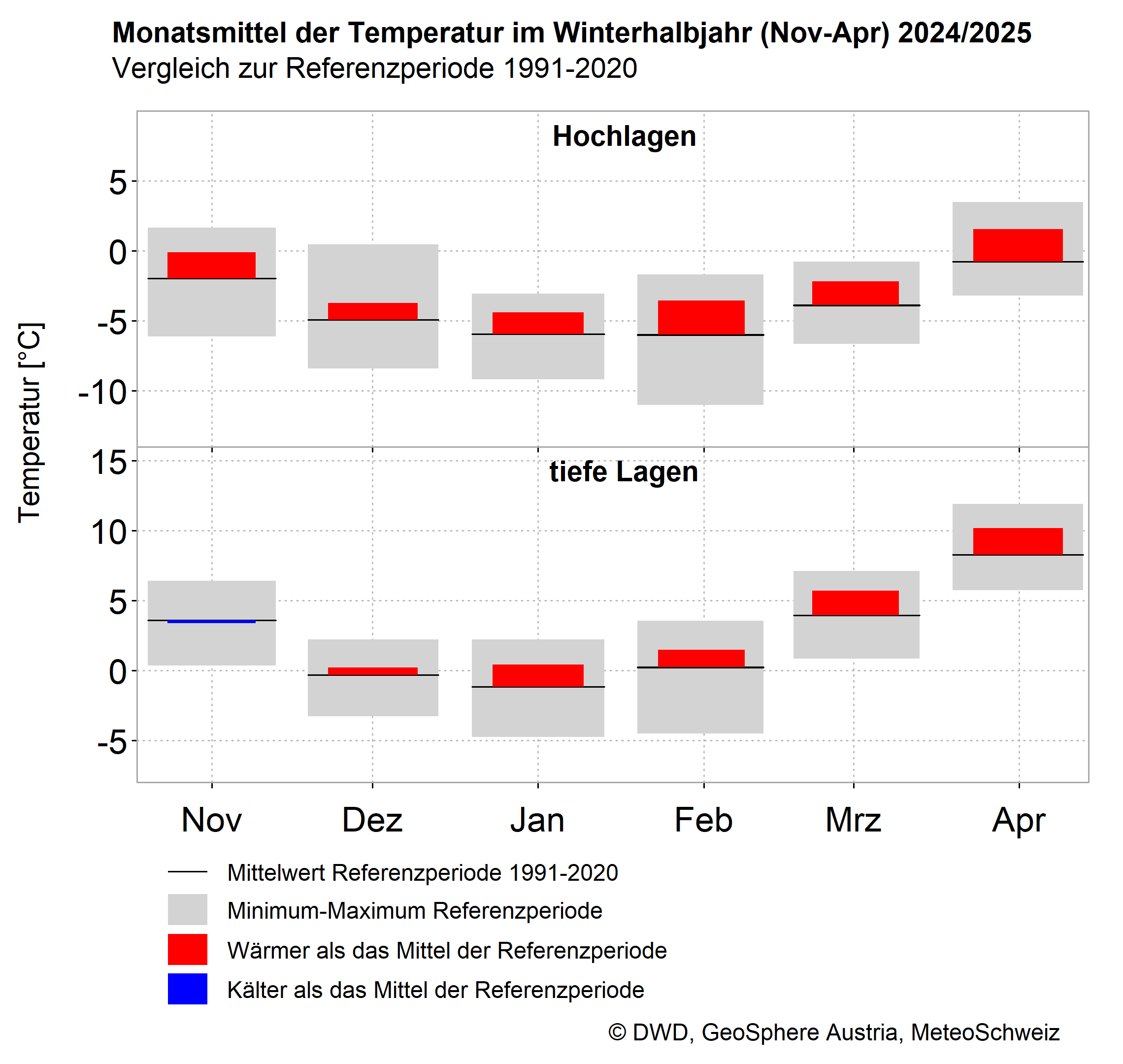
Alpine climate_winter-halfyear24-25_Temp.png
Alpine climate Germany, Austria, Switzerland: Monthly deviations in the winter half-year 2024/25 (November to April) compared to the reference period 1991-2020 for temperature (high and low altitudes respectively) © DWD, GeoSphere Austria, MeteoSwiss.
The many high-pressure weather conditions ensured plenty of sunshine in the Alpine region of Germany, Austria and Switzerland: at low altitudes, there were 9 per cent more hours of sunshine than in an average winter half-year, at high altitudes it was 16 per cent more.
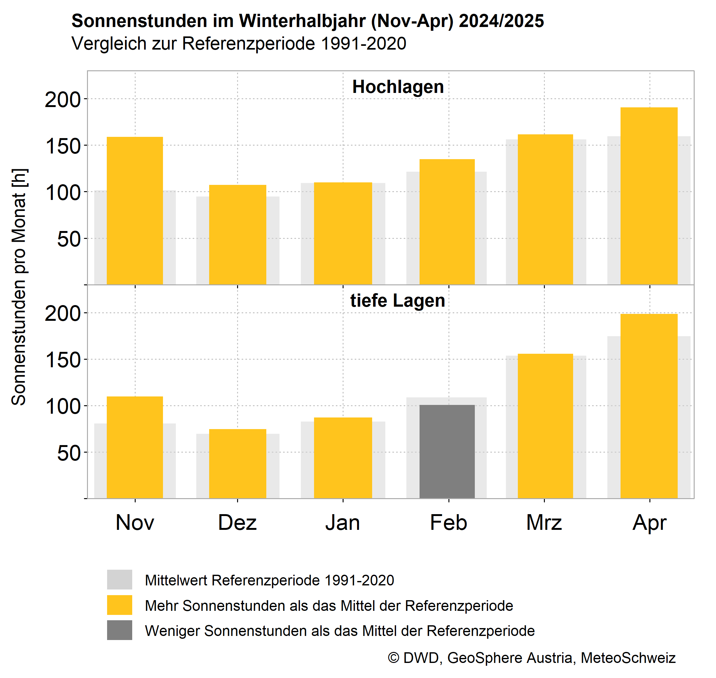
Alpine climate_winter-halfyear24-25_Sun.png
Alpine climate Germany, Austria, Switzerland: Monthly deviations in the winter half-year 2024/25 (November to April) compared to the reference period 1991-2020 for sunshine (high and low altitudes respectively) © DWD, GeoSphere Austria, MeteoSwiss.
The dry weather over long stretches also resulted in a winter half-year with little precipitation (-32 per cent on the northern side of the Alps, -28 per cent on the southern side).
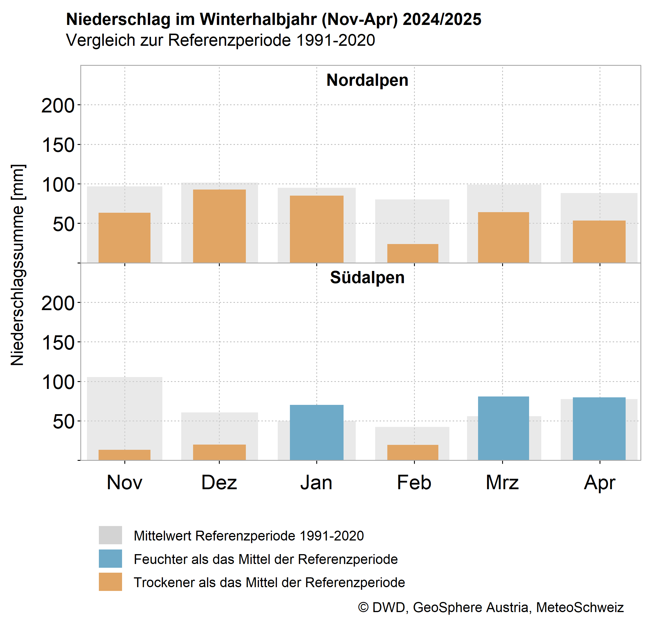
Alpine climate_winter-halfyear24-25_precipitation.png
Alpine climate Germany, Austria, Switzerland: Monthly deviations in the winter half-year 2024/25 (November to April) compared to the reference period 1991-2020 for precipitation (northern and southern Alps respectively). DWD, GeoSphere Austria, MeteoSwiss.
Due to the mild and low-precipitation weather, the amount of snow in many regions remained well below average. Somewhat average snow depths were recorded in parts of Valais, in the Engadine and generally on the southern side of the Alps in Switzerland.
An example of extremely little snow: from 7 February 2025, the daily snow depth at the Zugspitze weather station (D, 2962 metres above sea level) was almost consistently below the previous historical minima since snow depth measurements began.
However, it also became clear once again that even in a generally mild winter with little precipitation, it can snow a lot for a short time. In December 2024, shortly before Christmas, around one metre of fresh snow fell in some regions within five days, such as in Warth, Langen am Arlberg and Seefeld.
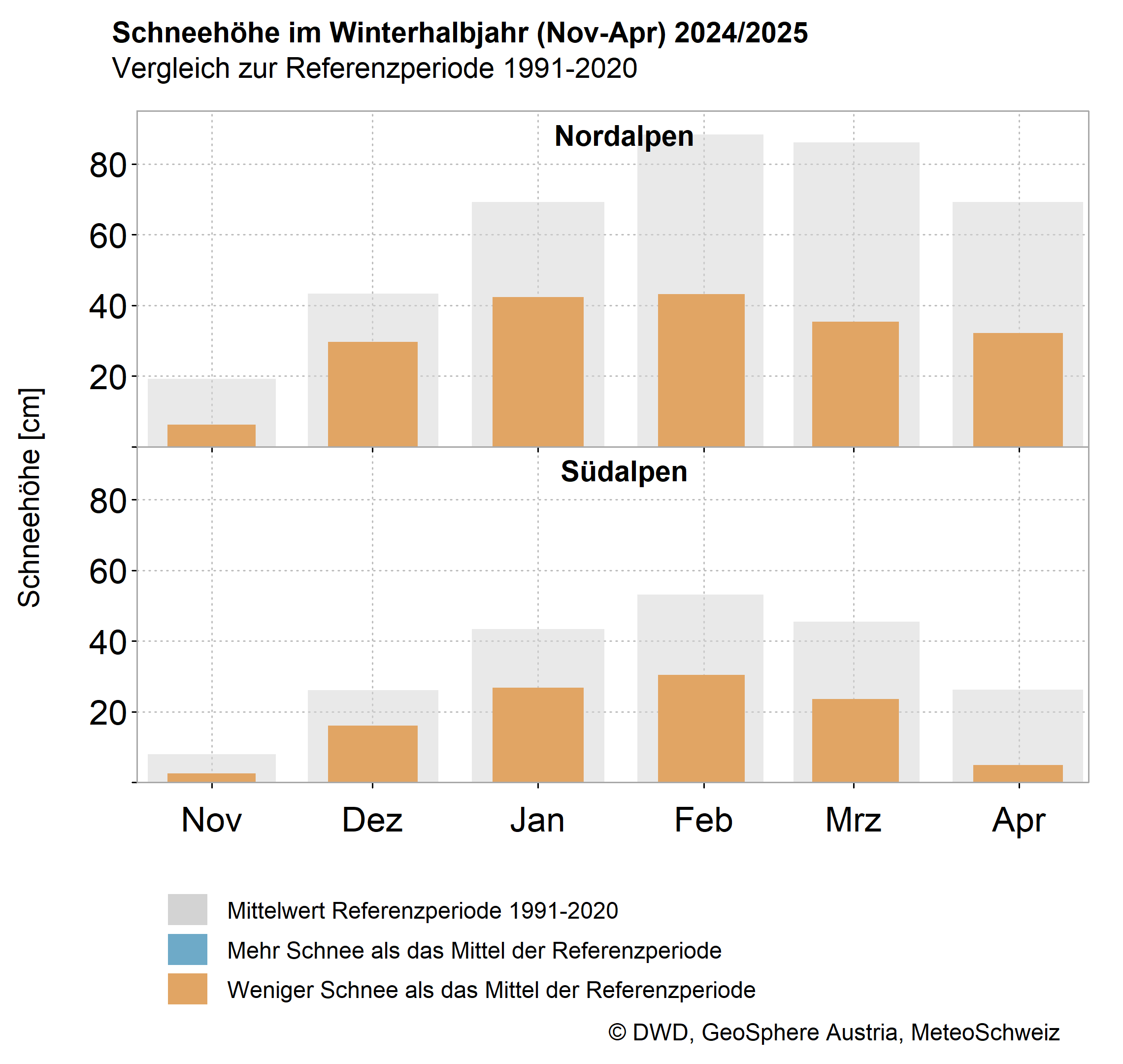
Alpine climate_winter-halfyear24-25_Snow.png
Alpine climate Germany, Austria, Switzerland: Monthly deviations in the winter half-year 2024/25 (November to April) compared to the reference period 1991-2020 for snow depth (northern and southern Alps respectively). DWD, GeoSphere Austria, MeteoSwiss.
To mark ‘125 years of the Zugspitze weather station’, the new Alpine Climate Report also contains a chapter on the importance of high-alpine weather stations and the history of observations on the Zugspitze.
Observatories for measuring and monitoring the weather were set up on peaks in the Alpine region very early on, sometimes under extreme conditions. This is why the series of summit measurements in Germany, Austria and Switzerland are among the longest in the world:
Measurements began at the Sonnblick Observatory of GeoSphere Austria (3106 metres above sea level) in September 1886. The weather station of the German Weather Service on Hohenpeißenberg (970 metres above sea level) began operations in January 1781, on the Zugspitze (2962 metres above sea level) in July 1900. MeteoSwiss has been taking measurements on the Säntis (2502 metres above sea level) since September 1882.
Translated with DeepL.com (free version)