140 noticeable earthquakes in Austria in 2024
In 2024, around 9300 seismic events were registered worldwide with the station network of the GeoSphere Austria earthquake service. Around 1600 earthquakes were localised in Austria, 133 of which were felt by the population. In addition, seven earthquakes from neighbouring countries were felt in Austria.
(Note: all data as of 30 December 2024, 11 a.m.)
In 2024, a total of 140 earthquakes were felt by the population in Austria. "This is well above the average of 67 perceptible earthquakes per year over the last ten years," says seismologist Rita Meurers from GeoSphere Austria, "but we are not observing a trend towards more earthquakes; the number of earthquakes in Austria fluctuates greatly from year to year. The large number in 2024 is mainly due to a remarkable series of earthquakes in the Waidring-Pillersee area in Tyrol, where 50 earthquakes were felt."
In 2024, 15 earthquakes in Austria reached a magnitude of 3.0 or higher. This number of strong quakes is three times higher than the average of the last ten years.
The strongest earthquake of 2024 in Austria occurred on 1 February at Semmering in Lower Austria. With a magnitude of 4.6, slight damage was caused to many buildings in the epicentre area. "For example, there were cracks in the plaster and walls, fallen plasterwork and damage to chimneys," says seismologist Meurers, "some roof tiles also fell down, books tumbled off shelves and small objects fell over."
The second strongest earthquake in Austria, which occurred on 23 January in the Waidring-Pillersee area with a magnitude of 3.9, also resulted in numerous reports of minor damage, such as plaster cracks, being received by the GeoSphere Austria earthquake service.
The number of instrumentally recorded earthquakes in Austria was also above the average of recent years at around 1600. This was due to several earthquake series and the densification of the seismological monitoring network in Austria. Co-operation with national and international institutions is also of great importance to the Earthquake Service in order to ensure optimal seismic monitoring of the entire federal territory.
The number of earthquakes felt in Tyrol in 2024 was particularly high at 70. The majority of these were caused by an unusual earthquake sequence in the Waidring-Pillersee area.
Styria is in second place in the national evaluation with 20 earthquakes felt. This figure is twice as high as the average for the last ten years, mainly due to the series of earthquakes near Leibnitz, Unzmarkt and Leoben.
This is followed by Lower Austria, where an average earthquake year was recorded with 16 earthquakes felt.
In Carinthia, 13 noticeable earthquakes occurred, nine of which had their epicentre in the Zell-Pfarre area.
There were nine felt earthquakes in Vorarlberg, with the centre of seismic activity near Wald am Arlberg.
Five earthquakes were felt in Upper Austria, four of them in the Steyrling area.
Seven earthquakes were felt in Austria from neighbouring countries. The epicentres were in the Czech Republic, Italy, Slovenia, Croatia and Switzerland.
The Austrian Seismological Service received around 13950 perception reports via the online perception form of the GeoSphere Austria earthquake service (quake report) and via the "QuakeWatch Austria" App ("QuakeWatch Austria"), which has been available since March 2021. The strongest quake in Semmering topped the list with more than 3500 reports.
The reports from the population provide information on the strength of the perceptibility and enable the degree of intensity to be determined on the European Macroseismic Scale EMS-98 (see below). They also make a significant contribution to determining the earthquake hazard in Austria. The GeoSphere Austria Earthquake Service would like to thank the population for the numerous reports.
Information on the terms magnitude and intensity
Magnitude is a measure of the energy released in the earthquake centre. It is determined from instrumental recordings (seismograms). The determination of magnitude is independent of damage and palpability and goes back to the American geophysicist Charles Richter.
The intensity describes the effects of an earthquake on the earth's surface. Most countries in Europe, including Austria, use the 12-level European Macroseismic Scale 1998 (EMS-98).
An earthquake with a magnitude of 3.4 occurred in the Zell-Pfarre area in Carinthia, near the border with Slovenia, at 01:02 on 9 January. It was felt strongly in the area of the epicentre and in Ferlach and woke many people from their sleep. Buildings were clearly shaken and some objects fell over. The quake was also clearly felt in Klagenfurt, Völkermarkt and Velden am Wörthersee. The epicentre intensity reached 4 to 5 degrees on the 12-level European Macroseismic Scale (EMS-98). By 23 February, a further eight significantly weaker earthquakes with an epicentre near Zell-Pfarre were felt by the population.
In Tyrol, an extraordinary series of earthquakes took place in the Waidring-Pillersee area from 9 January, which, in addition to hundreds of weak events, also brought with it several strongly felt earthquakes. The strongest quake occurred on 23 January at 04:50 with a magnitude of 3.9 and an epicentre intensity of 5 to 6 degrees on the EMS-98. There was slight damage to buildings in the villages around the epicentre, which was located west of Pillersee. This mainly involved small cracks in the interior and exterior walls as well as small pieces of plaster falling down. Objects were displaced or fell over. The quake was felt particularly strongly in Waidring, St. Ulrich am Pillersee, Erpfendorf, Kirchdorf and St. Johann in Tirol, as the analysis of a total of more than 2,300 reports from the population revealed. Reports of perceptions were also received from Bavaria.
The strongest event was preceded by several noticeable earthquakes, the quakes on 19 January at 03:30 (magnitude 3.4) and at 20:28 (magnitude 3.5), which caused some plaster cracks in the epicentre area and reached an intensity of 5 degrees on the EMS-98, were felt particularly strongly. A total of 46 earthquakes were felt in the Waidring area between 12 January and 12 February, followed by four more aftershocks by the end of the year. The series was accompanied by around 350 weak earthquakes that were only recorded by instruments.
A strong earthquake with a magnitude of 3.6 shook the area around the Fernpass in Tyrol in the night from 26 to 27 January at 00:06. Many people were startled and felt a strong tremor. A loud rumbling could be heard and plaster cracks were reported in isolated cases. More than 800 reports of this quake were received. The strongest tremors were felt in Nassereith, Lermoos, Ehrwald and Biberwier. The intensity reached a maximum of 5 degrees on the EMS-98.
The strongest earthquake of the year occurred on 1 February at 02:59 near Semmering, Lower Austria. With a magnitude of 4.5, numerous buildings were damaged, cracks in the plaster and walls, fallen plaster parts and damage to chimneys were reported and documented. Roof tiles fell off, books tumbled from shelves and small objects fell over. In the towns of Semmering, Breitenstein, Trattenbach and Steinhaus am Semmering, an intensity of 6 degrees on the EMS-98 was reached. The tremors were felt by the population in large parts of Lower Austria, Styria and Burgenland, in Upper Austria and occasionally as far as Salzburg and Tyrol. More than 3,500 perception reports were sent to the earthquake service via the online perception form and the QuakeWatch Austria app. By 9 May, six aftershocks with a maximum magnitude of 2.0 had been felt, which were only faintly perceptible.
Many people in southern Styria felt an earthquake at 17:20 on 1 February, the epicentre of which was 5 km southwest of Leibnitz near Heimschuh. The depth of the earthquake was only about four kilometres, so the tremors were strongly perceptible for the population in the epicentral area despite the relatively low magnitude of 2.5. Many people were frightened and fled from buildings, objects fell over and some minor damage to buildings, mainly small cracks and plaster cracks, was reported. The intensity reached 5 degrees on the EMS-98. 785 reports of the quake were received from the population. Two weak foreshocks had already been felt on 22 January. On 1 February, 50 minutes after the main earthquake, the first noticeable aftershock was weakly felt, followed by two further slight aftershocks in the area on 2 February.
The epicentre of a strongly felt earthquake with a magnitude of 3.6 was located between Gschnitz and Neustift in the Stubai Valley on 31 October at 20:19. Buildings were clearly shaken and furniture and objects moved. The Austrian Seismological Service received reports from Gschnitz, the Stubaital, the Wipptal and the greater Innsbruck area. The intensity reached 4 to 5 degrees on the EMS-98. A total of five noticeable earthquakes were recorded in this area in June, October and November.
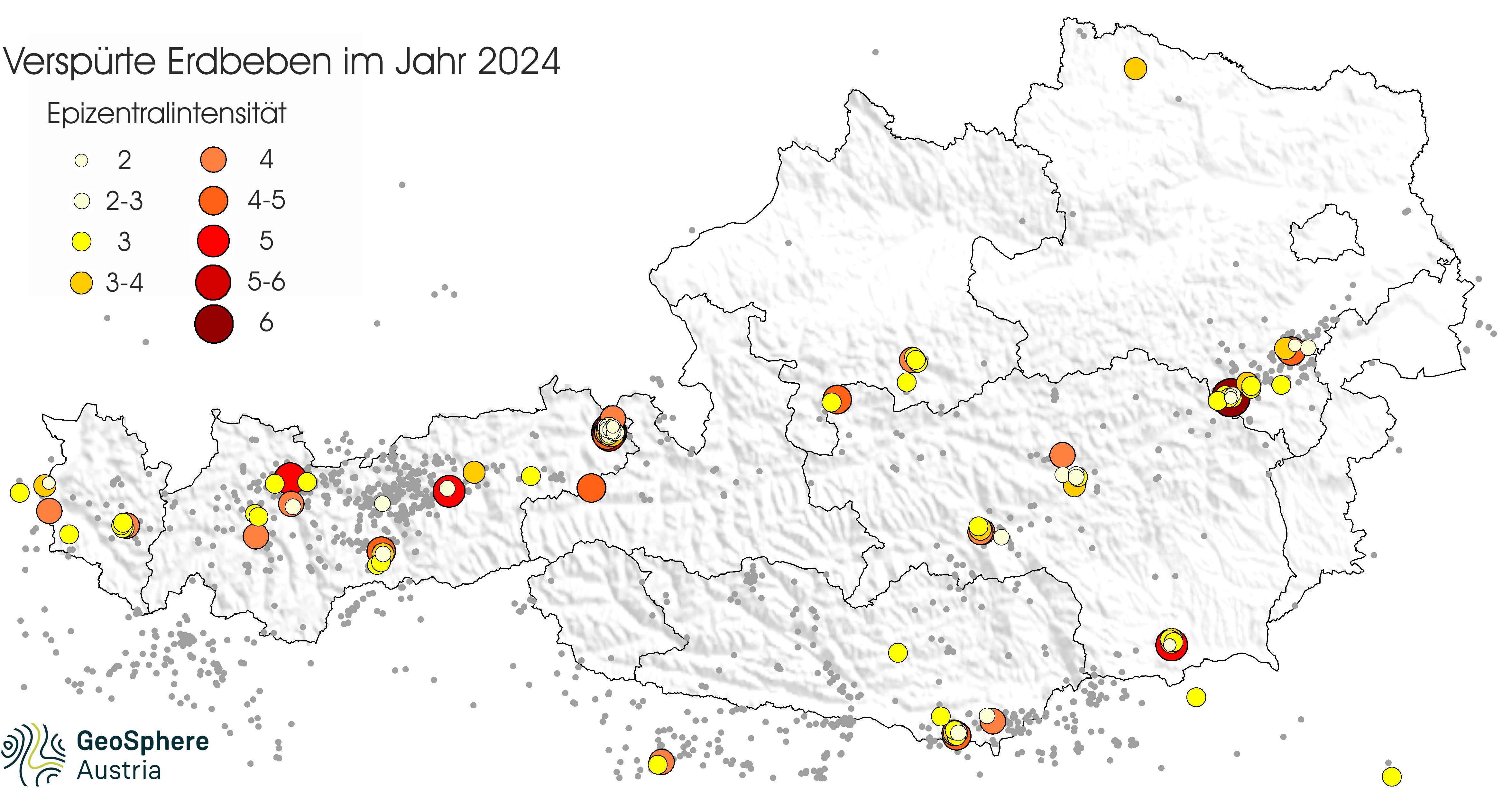
Earthquakes_2024.jpg
Earthquake 2024: Epicentre intensity (maximum strength of perceptibility) of the quakes felt by the population. For earthquakes with an epicentre abroad, the maximum intensity reached in Austria is indicated. In addition, the grey dots mark the instrumentally registered quakes. (Evaluation up to and including 30.12.2024, 11 am). Source: GeoSphere Austria.
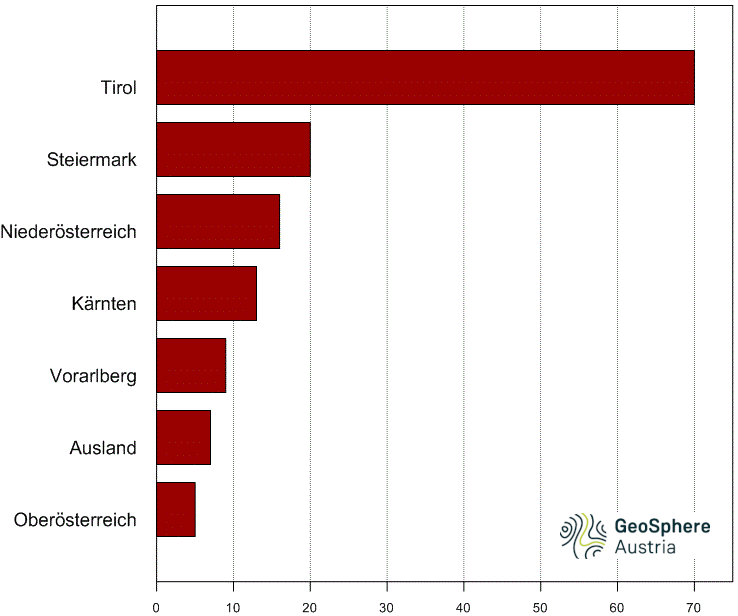
Earthquakes_2024_State comparison.png
Federal state comparison 2024: The graph shows how many felt earthquakes occurred in the individual federal states and abroad in 2024. (Evaluation up to and including 30.12.2024, 11 am). Source: GeoSphere Austria.
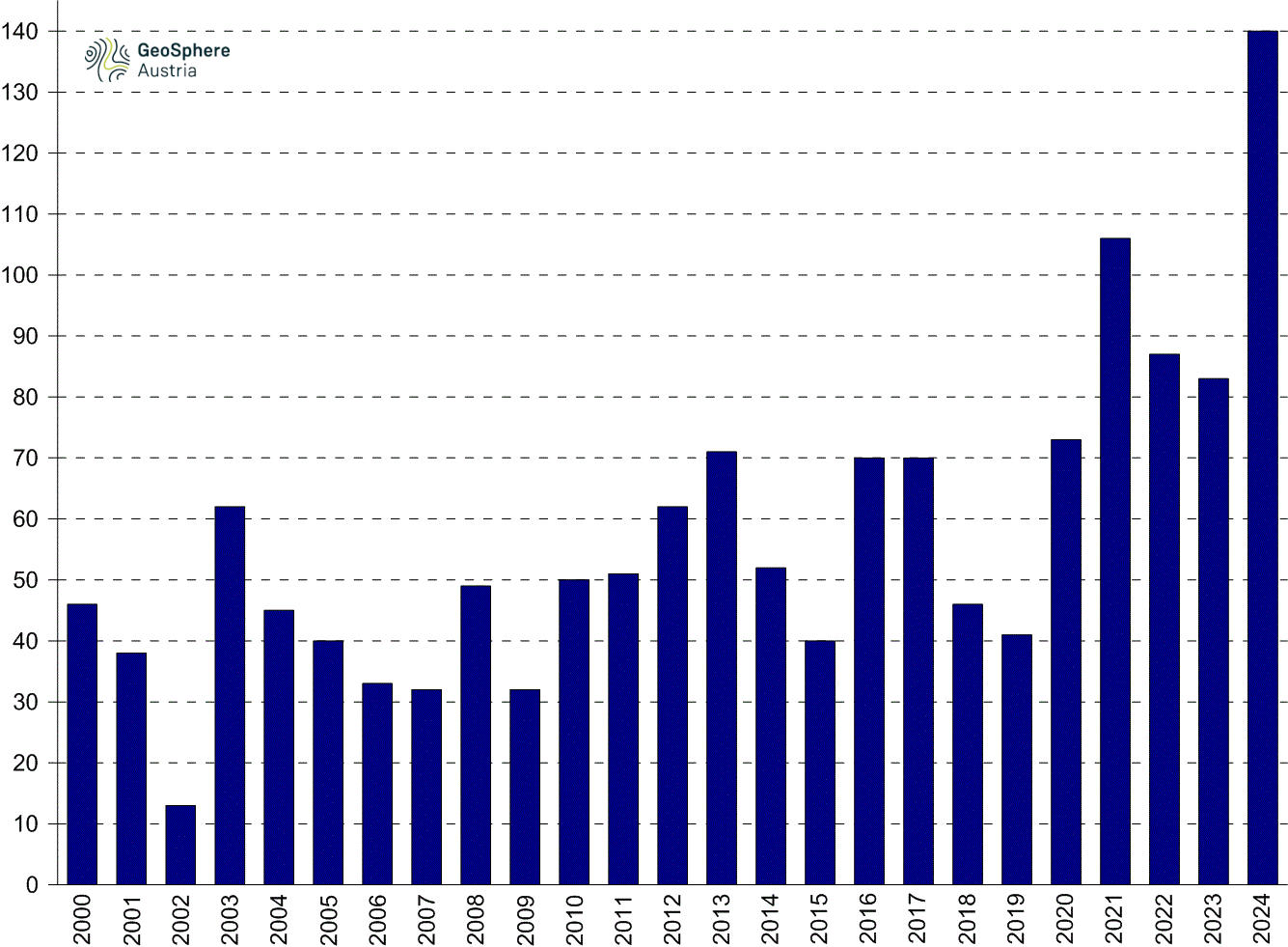
Earthquakes_felt_2020-2024_.png
Perceived earthquakes in Austria since 2000: On average, there were 57 perceived earthquakes per year in Austria between 2000 and 2024. (Evaluation up to and including 30.12.2024, 11 am). Source: GeoSphere Austria.
Translated with DeepL.com (free version)