The signs clearly point to El Niño
The ENSO (El Niño Southern Oscillation) weather phenomenon is difficult to predict and has far-reaching consequences worldwide. It can cause enormous damage in a wide variety of ways across almost every continent. There is a 96 per cent probability that it will persist into the winter months.
Drought and heat in Australia, southern Africa, India and Pakistan. Heavy rain and flooding in the north-west of the USA, Ecuador, Peru and south-east China. Storms in the North Pacific. Only in Europe does ENSO have a comparatively minor impact. The phenomenon is considered the strongest and most far-reaching short-term natural climate fluctuation on Earth. In the Pacific, atmospheric air currents change cyclically, thereby altering heat transport in the ocean.
El-Nino_ChatGPT.png
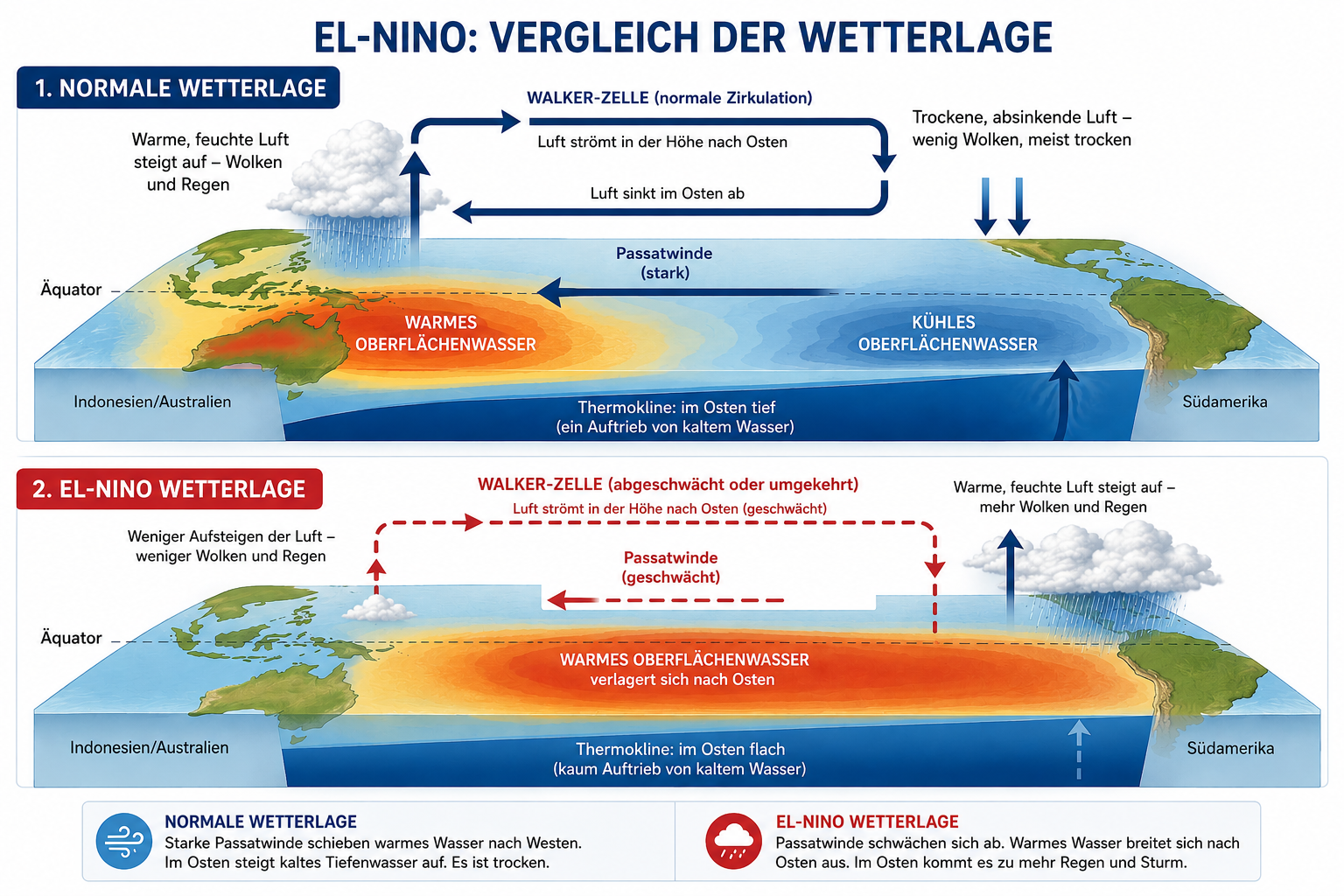
Circulation patterns under ‘normal’ and El Niño conditions. Under ‘normal’ conditions, the ascending branch of the Walker cell is located over the western Pacific, bringing heavy rainfall to the region; under El Niño conditions, it is located over the eastern Pacific. Source: Graphic created using ChatGPT.
ENSO consists of a warm phase (El Niño), a cold phase (La Niña) and a neutral phase. The interval between two El Niño events is irregular and varies from three to seven years. During this time, the surface water in the eastern Pacific warms more than usual and influences the weather in many regions of the world. Heat moves from the ocean into the atmosphere. With La Niña, the opposite occurs.
Natural climate fluctuations such as ENSO superimpose themselves on the long-term, human-induced warming trend. El Niño can temporarily exacerbate global temperatures and certain weather extremes, whilst La Niña can temporarily mitigate them. However, this does not affect the long-term trend: ENSO is not an additional, permanent driver of warming like greenhouse gases, but rather temporarily redistributes heat within the Earth’s system – primarily between the ocean and the atmosphere. ‘Even if we combine all the cooler El Niño years of the past decades, we see a clear long-term warming trend. This shows that human-induced climate warming continues to have an effect independently of these natural fluctuations,’ explains Marc Olefs, Head of the Department of Climate Impacts Research at GeoSphere Austria.
‘The signs clearly point to El Niño,’ emphasises Olefs. Although the National Oceanic and Atmospheric Administration (NOAA) currently still classifies the tropical Pacific as ENSO-neutral, it has already issued an El Niño watch: the probability of El Niño is 82 per cent for May to July and 96 per cent for it persisting into the winter of 2026/27. The IRI, WMO and several seasonal model ensembles also point clearly in this direction. It is particularly striking that some models and syntheses now consider a strong to very strong event on a par with historic El Niños such as 1997/98 or 2015/16 to be possible. Olefs: ‘It is therefore reasonable to say: El Niño is very likely, and the risk of a strong event is clearly increased — but it is still too early for statements such as ‘historic super El Niño’. The decisive factor will be how strongly the ocean and atmosphere in the tropical Pacific interact over the summer and autumn.’
‘El Niño is not a major driver of the weather in Austria and the Alpine region,’ explains climate researcher Marc Olefs. ‘Whilst it has very significant effects in many regions of the world, its signals reach us only in a weakened, indirect and unreliable form. For our winters, precipitation or heatwaves, the Atlantic-European circulation, regional weather patterns and long-term climate change are usually much more decisive.’
Continuously updated statistics