
Increased seismic activity in the Innsbruck-Hall area: Update
So far in 2026, a total of 53 earthquakes have been felt by the population in Austria, 50 of which had their epicentre within the country’s borders and three in regions close to the border abroad. However, a look at the national statistics reveals a clear regional concentration: according to the official earthquake catalogue, approximately 740 earthquakes have already been analysed in Tyrol in 2026 (408 of them since 1 August). This makes Tyrol by far the main focus of seismic activity throughout Austria.
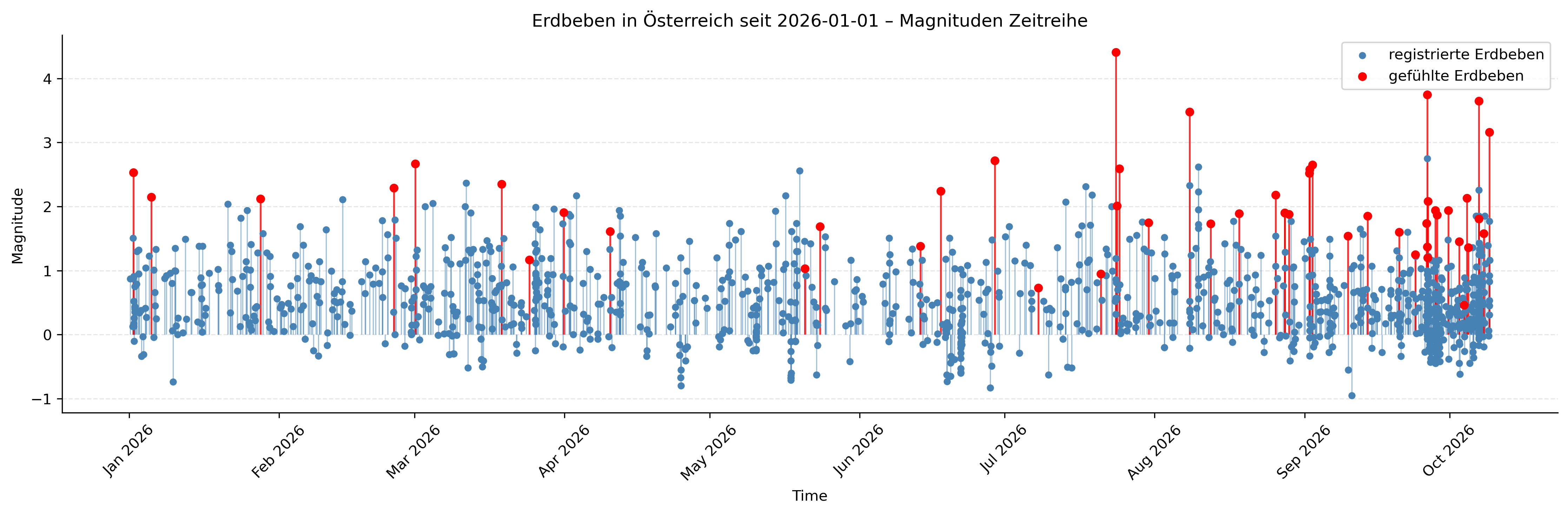
Magnitude_time series_Austria.png
Earthquakes in Austria since 1 January 2026 as a magnitude time series. © GeoSphere Austria.
Following a quieter first half of the year, seismic activity in Tyrol was characterised by a noticeable increase from the middle of the year onwards. Whilst in July mainly isolated tremors were felt in various parts of the country, the activity became increasingly frequent from the start of August 2026 onwards and was concentrated in the Innsbruck–Hall area.
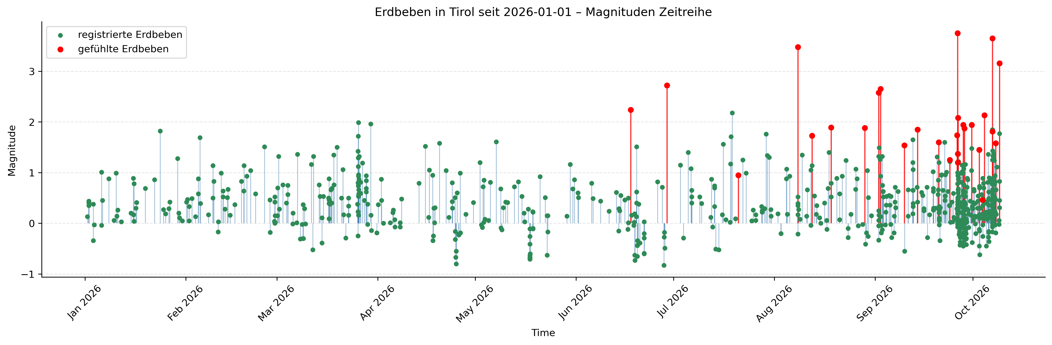
Magnitude_time series_Tyrol.png
Earthquakes in Tyrol since 1 January 2026 as a magnitude time series. GeoSphere Austria.
A detailed analysis of the data from the Austrian Earthquake Catalogue highlights the exceptional pattern of seismic activity in 2026:
Trend and peak activity: Following a moderate first half of the year, with an average of 35 to 45 earthquakes per month, the seismic service recorded a steady increase from July onwards. In August, the number rose to 56 recorded events, before the sequence peaked in September with 241 earthquakes. The increased frequency continued into the first few days of October, with 116 earthquakes already recorded.
Magnitude and focal depth: The majority of the approximately 740 earthquakes recorded and analysed occurred in the micro-range: Over 85 per cent of the earthquakes had a magnitude of less than 1.0. Around 13 per cent of the earthquakes fell within the range between ML 1.0 and 2.0, and only 6 reached a magnitude of 3.0 or more. With an average depth of around 7 km, the hypocentres were located very close to the surface of the Alpine crust.
Spatial distribution: The absolute focus of the activity lies in the greater Innsbruck area and the Inn Valley. By far the most affected municipalities in the epicentral area are Sistrans (145 earthquakes), Patscherkofel (110), Rinn (40) and Innsbruck (30), followed by Hall in Tirol, Karwendel and the Nordkette. In total, more than 289 earthquakes have been recorded in the local epicentre area since August (over 300 in the wider vicinity).
Perceptibility: Of the several hundred micro-earthquakes recorded, 33 tremors have been felt by the public in the immediate Innsbruck–Hall area since the beginning of August (or 28, according to the focused analysis of the core area). The strongest perceived intensities reached Level V on the European Macroseismic Scale (EMS-98) during the main earthquake on 26 September (ML 3.8) and the night-time earthquake on 7 October (ML 3.7).
How unusual is the situation? Historical context and notable earthquake series in Tyrol since 2004
What is unusual about the current situation is not so much the magnitude of any single event, but rather the high concentration of earthquakes felt by the public within the space of a few weeks. Within the current sequence, three geographical sub-areas can be distinguished:
- South-east of Innsbruck (Sistrans–Patscherkofel area): This is the main epicentre of the activity, with the majority of the micro-earthquakes and the most strongly felt major events, including the strongest earthquake in the series to date on 26 September (ML 3.8) and the notable night-time earthquake on 7 October (ML 3.7).
- East of Hall in Tyrol: This area marked the start of the heightened seismic activity on 8 August with a perceptible earthquake of magnitude ML 3.5.
- North of Innsbruck (Nordkette): In recent weeks, there have also been isolated minor earthquakes here (the strongest being ML 2.1 on 4 October).
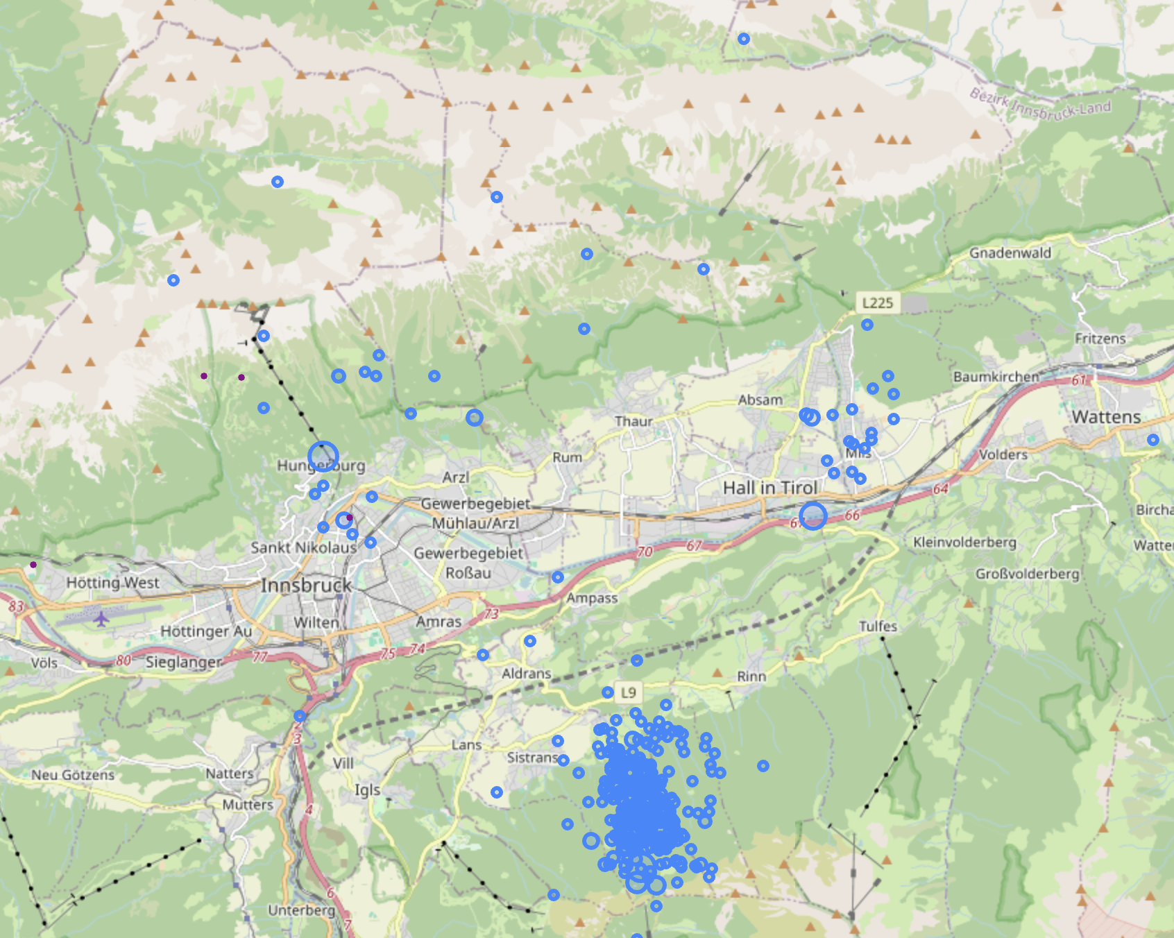
Earthquake series_Tyrol_09-10_2026.png
Earthquakes recorded in the Innsbruck–Hall area since 1 August 2026. The activity is concentrated in three geographical areas: east of Hall, south-east of Innsbruck and north of Innsbruck. © GeoSphere Austria.
The occurrence of such phases of frequent, swarm-like seismic activity over several weeks or months is a characteristic feature of Tyrolean seismicity. An analysis of data from the Austrian Seismological Service since 2004 shows that comparable sequences with a high local event density recur at regular intervals:
- Waidring / Pillerseetal area (2024): The most recent comparable sequence occurred in eastern Tyrol in the Pillerseetal valley (St. Ulrich, Waidring and the Loferer Steinberge). During 2024, 363 earthquakes were recorded there, 65 of which were felt by the public. The strongest event, on 23 January 2024, reached a magnitude of ML 3.9.
- Wildschönau (2021): In August 2021, a significant sequence of earthquakes shook the Wildschönau region. Despite a comparatively low total of 35 recorded earthquakes, the main event on 16 August reached a magnitude of ML 4.0 and was clearly felt throughout the Unterland region.
- Schönwies / Upper Inn Valley area (2020 & 2007): In August 2020, the Schönwies area in the Oberinntal recorded a series of 109 earthquakes, 23 of which were felt (the mainshock had a magnitude of ML 4.1 on 8 August 2020). As early as May 2007, a strong single earthquake with a magnitude of ML 4.2 occurred near Zams.
- Fulpmes / Stubai Valley (2017): In late autumn 2017, seismic activity was concentrated in the Fulpmes/Mieders area of the Stubai Valley. A total of 178 tremors were recorded (23 of which were felt). The strongest earthquake, on 3 November 2017, reached a magnitude of ML 3.9.
- Seefelder Plateau (2016): In July 2016, the Seismological Service recorded a series of 139 micro-earthquakes near Seefeld in Tyrol, 14 of which were felt by the public (maximum ML 3.5 on 25 July 2016).
- Thaur / Inn Valley area (2013): In August 2013, a series of noticeable tremors also occurred near Thaur, in the immediate vicinity of the current epicentral area. Of a total of 19 recorded events, the main earthquake on 9 August 2013 reached a magnitude of ML 3.7.
- Wattens / Vomp area (2010): One of the most extensive series of the last two decades took place in the Inn Valley in autumn 2010. Over 420 earthquakes were recorded in the Wattens and Vomp area (17 of which were felt), with the strongest event on 19 October 2010 reaching a magnitude of ML 4.0.
These historical comparisons illustrate that periods of closely successive, perceptible tremors in Tyrol are not an unusual phenomenon, but rather a recurring pattern of Alpine tectonics. The Austrian Seismological Service continues to monitor developments closely. Further noticeable aftershocks are possible in the coming days and weeks; however, there are no indications of an imminent major earthquake.
Even before the systematic recording of data began in 2004, significant earthquakes occurred repeatedly in the region. Thanks to historical earthquake research – in which written sources, chronicles and reports of building damage have been critically analysed and re-evaluated using modern seismological methods – these historical events have been precisely characterised, localised and classified according to their intensity:
- Earthquake near Hall in Tyrol (17 July 1670): The strongest earthquake ever recorded in the Tyrolean Inn Valley reached an estimated intensity of VIII (EMS-98) or a magnitude of M ~ 5.6. It caused massive damage to buildings in the Hall and Innsbruck areas, the collapse of church towers and at least nine fatalities.
- Earthquake near Innsbruck (22 December 1689): With an estimated intensity of VII–VIII (EMS-98) and a magnitude of M ~ 5.4, this winter earthquake caused severe damage to churches, monasteries, the castle and historic buildings in the Innsbruck urban area as well as in Hall.
- Innsbruck earthquake (4 January 1572): Another significant historical event in the Inn Valley, with an intensity of VI–VII (EMS-98) and a magnitude of M ~ 4.4, which led to cracks forming in buildings and damage to defences (such as the Inn Tower).
Further historic major earthquakes (18th & 19th centuries): In the centuries that followed, historical research also recorded significant tremors in the Inn Valley, including the earthquakes of 28 March 1706 (I0 = VI EMS-98), 18 August 1727 (I0 = VI–VII EMS-98) and 8 August 1872 (I0 = VI EMS-98), each of which caused panic and damage to the Mamposterie in Innsbruck, Hall and Schwaz.
Seismic activity in the greater Innsbruck–Hall area cannot be regarded as an isolated phenomenon, but is the direct result of the complex Alpine crustal dynamics of the Eastern Alps. This is caused by the ongoing north–south collision between the Adriatic microplate and the Eurasian Plate, during which the Alpine crust is severely compressed, deformed and broken up into individual blocks:
Telfs Transfer Fault (TF) & Brenner Fault (BF): The Inn Valley forms a prominent tectonic junction in western and central Tyrol. Deep crustal fault zones such as the Telfs Transfer Fault and the Brenner Fault system absorb significant portions of the tectonic stresses and lead to the regular occurrence of earthquakes.
Characteristics of focal depths: The latest analyses from 2026 show that focal depths in the Innsbruck–Hall area, averaging around 7 km, lie very close to the surface of the Alpine crust. This explains why even moderate-magnitude events (such as ML 3.5 to 3.8) cause very distinct shaking of intensity level V (EMS-98) in the epicentral area, as well as loud rumbling heard by the population.
Influence of unconsolidated sediments: The Inn Valley is also characterised by deep sedimentary fillings. These unconsolidated sediments often act as local amplifiers for seismic waves (due to local effects and the influence of zonal sediments), which further intensifies the perceptibility of tremors in the core area of Innsbruck–Hall.
Further earthquakes and additional felt aftershocks in the region are possible. However, it is not possible to predict how long the current phase of activity will last, or when further events might occur and at what magnitude.
The current cluster of events does not indicate that a stronger earthquake is imminent. The Austrian Seismological Service is continuously monitoring seismic activity in the Innsbruck–Hall area and is constantly analysing new events.
Seismic monitoring stations provide information on the location, depth and magnitude of an earthquake. In order to be able to assess, in addition, how strongly an event was felt in different locations and what impact it had on people, objects and buildings, reports of how the event was felt by the public are particularly important.
A big thank you to everyone who has already reported their observations and perceptions to us. Every single piece of feedback helps us with our analysis: the more reports we receive, the more accurately we can determine the intensity, the spatial extent of the tremors and local variations in their effects. Anyone who felt an earthquake can use the observation form on the GeoSphere Austria website or the QuakeWatch Austria app. The reports are incorporated into the macroseismic analysis carried out by the Austrian Seismological Service.
Translated with DeepL.com (free version)