
Increased seismic activity in the Innsbruck–Hall area
Since early August 2026, the Austrian Seismological Service has been observing a notable period of increased seismic activity in the Innsbruck–Hall area. More than 270 earthquakes have been recorded in the region since then. According to the latest analysis, 20 of these events were felt by the public.
What is unusual here is not so much the magnitude of any single quake as the clustering of felt earthquakes within a few weeks. Tyrol is generally one of the most seismically active regions in Austria and repeatedly experiences periods of increased seismic activity. The Seismological Service is continuously monitoring and analyzing the current series of earthquakes.

Tyrol_series_all_earthquakes_since_01-08-2026.png
Earthquakes recorded in the Innsbruck–Hall area since August 1, 2026. The activity is concentrated in three geographical areas: east of Hall, southeast of Innsbruck, and north of Innsbruck. © GeoSphere Austria / topography: OpenStreetMap.
The current seismic activity is not evenly distributed across the region but is concentrated in three specific areas. The activity phase began on August 8 east of Hall with an earthquake of magnitude ML 3.5. Additional smaller events, some of which were felt, followed in August and September.
By far the largest portion of the current series is located southeast of Innsbruck in the Sistrans–Patscherkofel area. Numerous small earthquakes have been recorded there since early September. This area also saw the two strongest events of the current series: the ML 3.8 earthquake on September 26 and the ML 3.7 earthquake on October 7.
A third area of activity lies north of Innsbruck. There, too, several minor earthquakes have been recorded in recent weeks and were occasionally felt by the public. The strongest event felt so far in this area reached a magnitude of ML 2.1 on October 4.
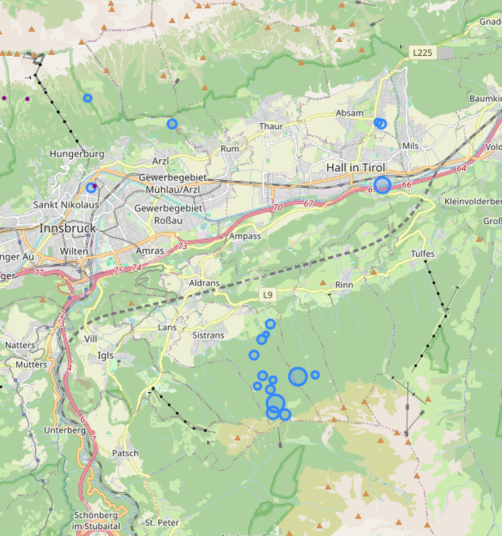
Tyrol_series_earthquakes_felt_since_01-08-2026.png
Earthquakes felt by the public during the current phase of activity in the Innsbruck–Hall area. According to the latest analysis, 20 events have been felt since early August. © GeoSphere Austria / topography: OpenStreetMap.
As of now, 20 earthquakes have been felt by the public in the three active zones since early August. The following table lists the events that have been classified as “felt” so far.
The strongest event in the current series to date occurred on September 26 at 9:56 a.m. CEST southeast of Innsbruck. The earthquake reached a magnitude of ML 3.8 and was clearly felt across a wide area around Innsbruck and along the Inn Valley.
The Seismological Service received more than 1,700 reports of the event. Many people described a brief, powerful jolt or strong shaking, accompanied by a loud rumbling. Small and unstable objects fell over in some cases; wall hangings and other small items shifted, and a few people left buildings in fright. In isolated cases, very minor damage such as hairline cracks in walls or small pieces of plaster falling off was reported.
The main quake was followed by numerous smaller aftershocks, several of which were also felt by the public.
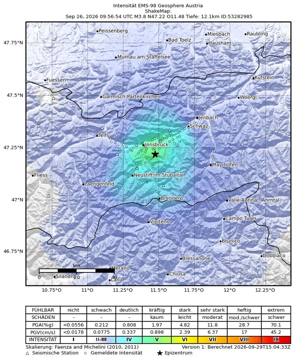
Shakemap_earthquake_26-09-2026_Innsbruck.jpg
ShakeMap (Erschütterungskarte) des Erdbebens der Magnitude ML 3,8 vom 26. September 2026 südöstlich von Innsbruck. Die Erschütterungen wurden vor allem im Großraum Innsbruck und entlang des Inntals deutlich wahrgenommen. © GeoSphere Austria / USGS.
On October 7 at 3:02 a.m. CEST, another earthquake with a magnitude of ML 3.7, which was clearly felt, occurred about 7 km southwest of Hall in Tirol. The epicenter was again located in the active zone southeast of Innsbruck.
By early morning, the Austrian Seismological Service had already received more than 800 reports of the earthquake being felt. Many people described noticeable shaking or swaying of the ground and buildings. An audible rumbling was reported particularly frequently. Numerous people were awakened from their sleep by the tremor.
Some reports also included information about possible minor damage, which is still being evaluated in detail.
At 3:10 a.m. CEST, an aftershock with a magnitude of ML 1.9 followed. According to the latest analysis, another aftershock at 4:18 a.m. CEST with a magnitude of ML 1.4 was also felt by the public.
The Innsbruck–Hall region is located in a tectonically active area. In fault zones within the Earth’s crust, slow underground movements cause stress to build up in the rock. If this stress exceeds the rock’s strength, a fracture occurs. The energy released in this process propagates in the form of seismic waves and is perceived at the surface as an earthquake. Tyrol is generally one of the most earthquake-prone states in Austria. Periods of comparatively low activity can alternate with significantly more active phases. What is particularly striking about the current series is the large number of earthquakes that have been felt by the population within just a few weeks.
Further earthquakes and additional felt aftershocks in the region are possible. However, it is not possible to predict how long the current phase of activity will last or when—or with what magnitude—further events will occur. The current cluster of events does not indicate that a stronger earthquake is imminent. The Austrian Seismological Service continuously monitors seismic activity in the Innsbruck–Hall area and evaluates new events on an ongoing basis.
Seismic monitoring stations provide information on the location, depth, and magnitude of an earthquake. To further assess how strongly an event was felt in different locations and what effects it had on people, objects, and buildings, reports of felt effects from the public are particularly important.
A big thank you to everyone who has already reported their observations and perceptions to us. Every single report helps us with our analysis: The more reports we receive, the more accurately we can determine the intensity, the spatial extent of the shaking, and local differences in the effects. Anyone who felt an earthquake can use the observation form on the GeoSphere Austria website or the QuakeWatch Austria app. These reports are incorporated into the Austrian Seismological Service’s macroseismic analysis.
Translated with DeepL.com (free version)