
Heatwave with no end in sight exacerbates extreme drought
Over the coming days, it will become very hot, particularly in eastern Austria. As was the case in June, temperatures of 38 to 39 degrees are expected, and in some places perhaps even 40. However, it is still unclear how long the current heatwave will last. The prolonged, extreme drought in many parts of the country is set to continue – despite isolated thunderstorms and showers.
The heat will build up progressively across the whole of Austria until Friday. According to the latest forecasts from GeoSphere Austria, Friday itself will be the hottest day. ‘There is a clear east-west gradient,’ explains meteorologist Thomas Turecek. In other words, whilst it will be hot across the whole country, it will once again be particularly hot in the east. ‘Some stations in the eastern lowlands may reach 38 to 39 degrees. Perhaps even 40, similar to June,’ says Turecek. Back then, on 28 June, the Vienna-Innere Stadt weather station recorded 40.0 degrees, and the following day, the station in Bad Deutsch-Altenburg recorded 40.1 degrees.
For Sunday and Monday, the forecast models indicate a further rise to 35 degrees and above in some places, although the weather situation is ‘generally more unstable’, says Turecek. ‘The likelihood of showers and thunderstorms is increasing in the mountainous regions. However, this does not mean an end to the heatwave just yet: ‘There is no major change in the weather in sight. What is missing at the moment is a clear drop in temperature of ten to 15 degrees.’
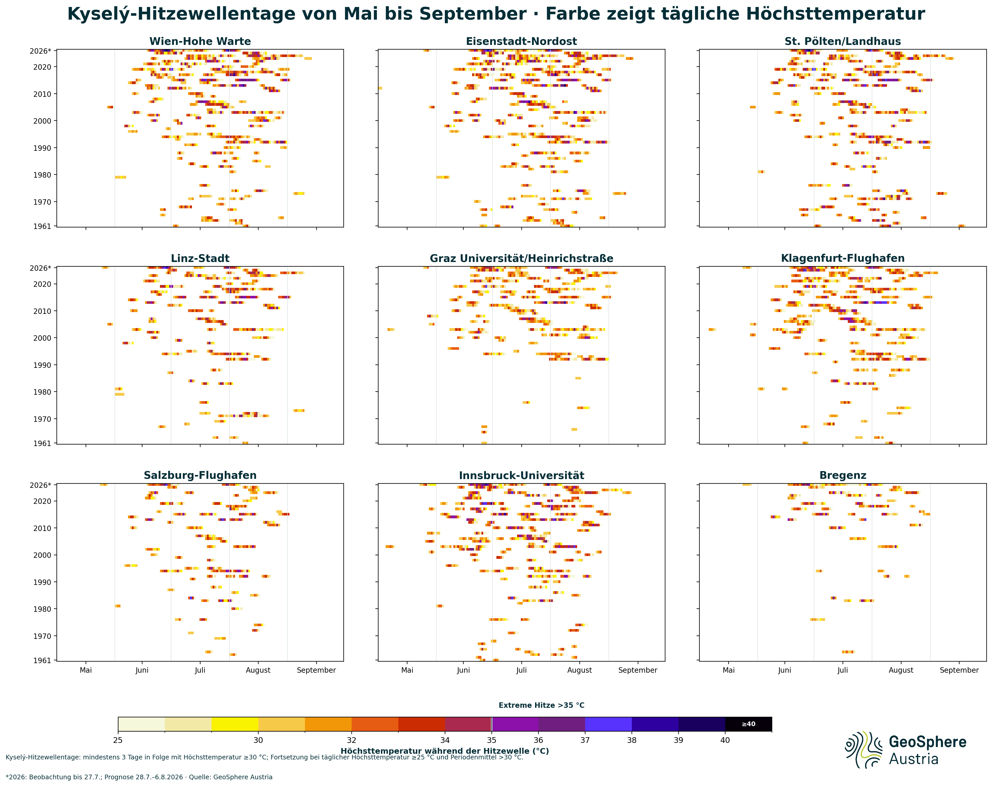
In the west and south of the country, the current heatwave is already the third of the year. ‘The first began on 24 May and lasted between five and nine days. The second heatwave, which began in mid-June, affected the whole of Austria and lasted between 18 and 35 days in the lowlands – an unusually long period,’ summarises climatologist Alexander Orlik from GeoSphere Austria. What’s more: According to Kysely’s definition, this heatwave is still ongoing in some regions of Austria, as the daily maximum air temperatures there have not yet fallen below 25 degrees, nor has the average of the daily maximums fallen below 30 degrees. This includes, for example, the weather stations in Bregenz and Eisenstadt.
Heatwave_Kysely.png
Kysely heatwave days from May to September. © GeoSphere Austria.
The number of heatwave days is rising more sharply than the number of heatwaves. For example, from the 1940s to the 1980s, there were still around one to two heatwaves per year, each bringing an average of one to eight heatwave days. In the 2010s and 2020s, there are now two to three heatwaves per year, bringing an average of five to 25 heatwave days. By contrast, the number of years without a heatwave has fallen significantly. ‘The heatwave season has also lengthened. The earliest start in the period from 1961 to 1990 was 1 June, but in the period from 1991 to 2020 it was as early as 29 April,’ calculates Orlik. The absolute maximum air temperatures during a heatwave have risen by around three degrees from the 1980s to the 2020s.
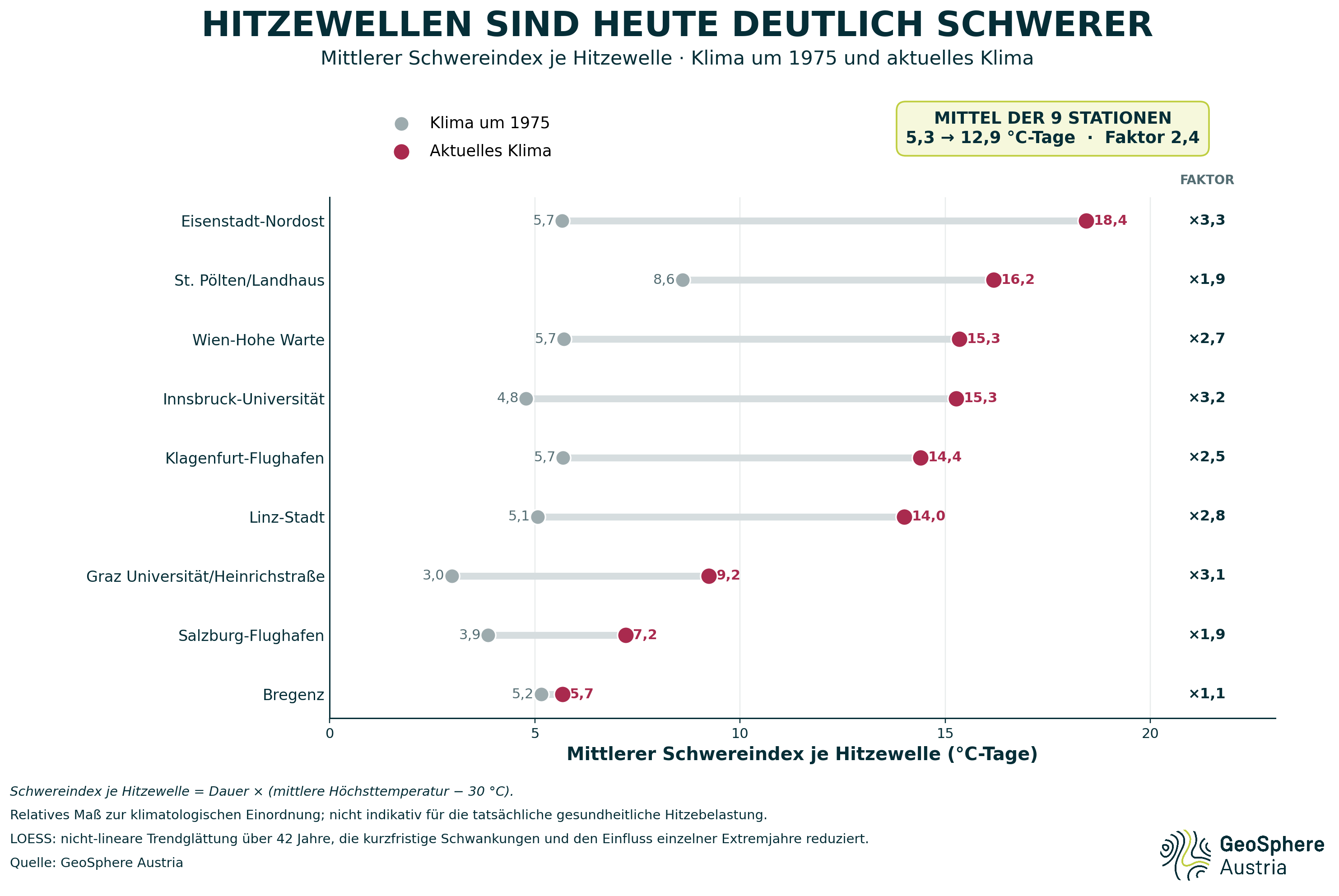
In addition, a severity index – which combines the duration and average maximum temperature of a heatwave – shows just how much the potential for heat-related stress has increased. Averaged across the nine stations in the provincial capitals, this index rose from 5.3 to 12.9 degree-days between the climate around 1975 and the current climate – an increase by a factor of 2.4. ‘Heatwaves are not only occurring more frequently today; they often last much longer and reach higher temperatures. This results in a significantly increased potential for health impacts,’ explains climate researcher Marc Olefs from GeoSphere Austria. How severely the heat is actually felt depends not only on air temperature but also on humidity, wind and solar radiation. These factors are taken into account when assessing the perceived temperature and, consequently, in GeoSphere Austria’s heat warnings. Olefs: ‘The extent to which these risks will continue to increase in the future depends largely on how quickly global greenhouse gas emissions fall: consistent climate action can limit further escalation, whilst adaptation and heat protection measures are already indispensable today.’
Heatwave_Severity-index.png
Average severity index per heatwave. © GeoSphere Austria.
The heat is also exacerbating the drought in Austria, which has now been ongoing for months. ‘There has been little change in July to the low-precipitation conditions that have prevailed since December 2025,’ says GeoSphere climatologist Orlik. “Rainfall in July was often too low to prevent the ongoing drought from worsening further.” Since the start of the year, there is still a shortfall of around 30 per cent on normal rainfall levels: ‘According to the climate average, the nationwide average rainfall should have been 609 millimetres by 27 July. So far, however, only 426 millimetres of rain have fallen. This means that Austria has not experienced such low rainfall in the first seven months of a year – at least since the beginning of the 20th century.’
Frequent periods of high-pressure weather with plenty of sunshine and long breaks between rainfall, particularly in the second half of May and June as well as at the end of July, led to very high evaporation rates, which further increased the moisture deficit in the soil. Precipitation was similarly low in 1971 and 2003. Nevertheless, the deficits compared with the climate average – at minus 27 per cent and minus 25 per cent respectively – were slightly lower than in 2026.
Translated with DeepL.com (free version)