
Combined Success – Carinthia Civil Protection Exercise
From 13 to 15 November 2026, the largest civil protection exercise ever held in Austria took place across the whole of Carinthia. Thousands of people from public authorities, emergency and rescue organisations, the Austrian Armed Forces, institutions and companies trained together in preparation for a real-life emergency.
Alongside the Red Cross and the Samaritan Federation, mountain rescue, water rescue, mine and cave rescue teams, as well as dog units, were also deployed. Kelag Energie und Wärme, Kärnten Netz, Austrian Power Grid, Verbund Hydro Power, ÖBB Infrastruktur and GeoSphere Austria took part as civilian partners and representatives of critical infrastructure. Numerous media outlets reported on the event in the run-up to the exercise and also on an ongoing basis whilst the training operations were taking place. All districts, as well as the two statutory cities of Villach and Klagenfurt, convened their own crisis management teams. The provincial crisis management team also met – this is where all efforts to manage a disaster converge – and the so-called ‘beacons’ were activated in the municipalities. These are emergency contact points for the public, equipped with emergency power supplies, in the event of disasters or a blackout. In an emergency, information is available there and assistance can be organised. The exercise scenario involved a series of severe earthquakes – in commemoration of the earthquake that struck Friuli-Venezia Giulia exactly 50 years ago.
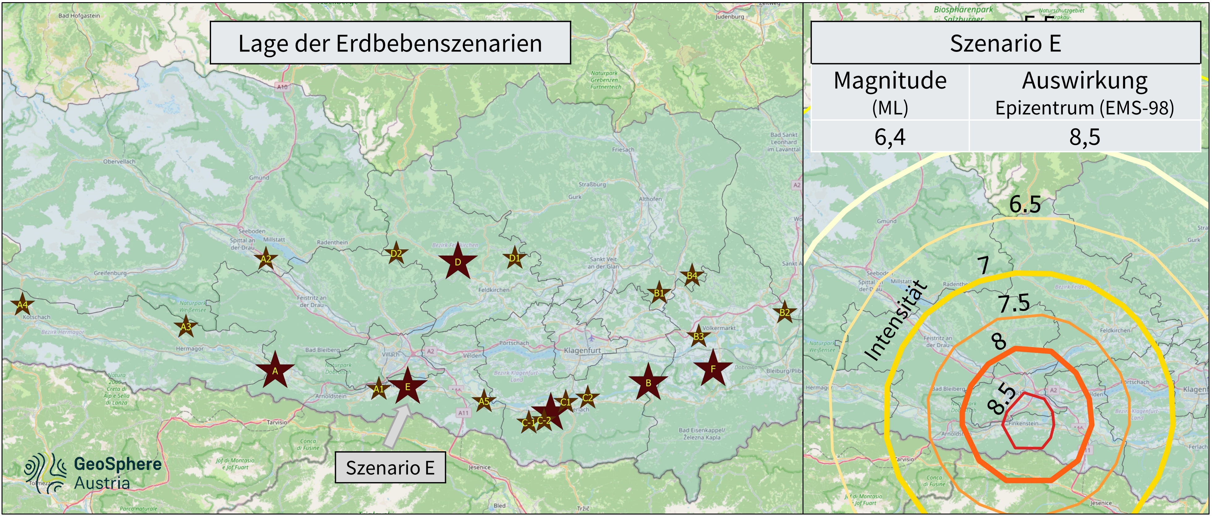
The Earthquake Service’s contribution involved developing earthquake scenarios and providing technical support to the Provincial Crisis Management Team in conducting the exercise. For each exercise location, an intensity value was first determined according to the European Macroseismic Scale (EMS-98), based on the earthquake damage data provided by the districts and municipal authorities. The intensity values were then used to adapt suitable models and to develop earthquake scenarios. The resulting ShakeMaps illustrate the spatial distribution of the expected earthquake effects. In the event of an emergency, these maps are generated automatically and made available to the Provincial Alarm and Warning Centre. As the exercise planning envisaged significant damage to (critical) infrastructure throughout Carinthia, even very rare seismic events with magnitudes of up to 6.4 ML were taken into account. In one of the scenarios, a strong earthquake with a focal depth of 8 km was assumed. According to model calculations, this would result in an intensity of approximately 8.5 degrees in the epicentral area, and an intensity of 7 degrees (moderate damage to buildings) at a distance of 30 km.
Combined_success_earthquakes_scenaries.jpg
Example of the earthquake scenarios provided for Combined Success 2026: (left) Overview of the locations of the epicentres; (right) Illustration of the effects of a magnitude 6.4 earthquake in Scenario E. In the epicentral area, severe to catastrophic damage to buildings is to be expected at an intensity of 8–9 on the Mercalli scale. Moderate damage to buildings (Grade 7) is expected at distances of up to approximately 25 km from the epicentre. © GeoSphere Austria/Hausmann.
The Carinthia regional office of GeoSphere Austria was involved in the planning of the civil protection exercise from the outset and supported it by developing possible realistic weather scenarios. Using its own tool, historical weather situations can be simulated realistically on the basis of time-staggered and continuously updated model data and measured values. During the exercise, the necessary weather information was provided, and members of the provincial crisis management team were given ongoing advisory support regarding the actual weather conditions, for example concerning the conduct of potential helicopter flights. The disaster scenarios tested during the exercise ranged from rescue and evacuation operations following road and train accidents, as well as building and bridge collapses, and transformer fires causing widespread power cuts, right through to a chemical accident involving the release of toxic gases at the Donau Chemie plant in Brückl and the Infineon plant in Villach. Specifically for chemical accidents, a dedicated particle dispersion model (“ENVINER”) is run by the environmental department at GeoSphere Austria to assess the spread of toxic substances. The results are then made available to crisis management teams and emergency services in the event of a disaster. The simulation shows which areas are particularly affected due to the terrain and current wind conditions and where, for example, evacuation measures may be required.
Since 1800, a total of 13 earthquakes causing minor damage to buildings have been documented in the Austrian Earthquake Catalogue. Moderate damage, however, was caused in 1857 (Rosegg) and 1976 (two earthquakes in Friuli). According to sources, the strongest historical earthquakes (*) also resulted in fatalities. The earliest known earthquake occurred in 1201 and had its epicentre in the Katschberg area. However, the reconstruction of the focal parameters is subject to considerable uncertainty. According to historical sources, several churches and brick-built houses collapsed during this earthquake. The very strong earthquake of 1348 triggered a massive rockslide on the Dobratsch. It destroyed palaces and severely damaged castles; fires resulting from the earthquake are also recorded. The epicentre was probably situated south of the present-day border between Carinthia and Friuli. The reconstructed magnitude is 6.8. Only recently was the magnitude of the 1690 earthquake near Arriach reconstructed as 6.4 – the highest known magnitude for an earthquake in Austria to date. Damage occurred in many towns and cities across Carinthia, and numerous buildings collapsed.
On average, six earthquakes that were felt have occurred in Carinthia each year since 2000. So far in 2026, two earthquakes strong enough to be felt have been recorded. In addition, the seismic monitoring network records around 110 earthquakes per year. Earthquakes causing minor damage to buildings have occurred here approximately every 25 years in the past, most recently in 2013 near Bad Eisenkappel.
*) References
Hammerl, C. und Lenhardt, W. (1997). Erdbeben in Österreich. Leykam Verlag Wien, Graz 1997.
Hammerl, C. (2024). Fallstudie zum Erdbeben vom 4. Dezember 1690 in Kärnten. Potenzial und Grenzen makroseismischer Daten und ihr Einfluss auf die seismische Gefährdung. Vortrag für Kärtner Landesmuseum, Klagenfurt am 15. Februar 2024.
Hammerl, C. (2025). Das Ostalpen Erdbeben vom 15. Jänner 1348 im Spiegel der Quellen und Literatur – eine unendliche Geschichte. 140 – 154. In: Budsky, A. (Hrsg) 2025: Kärnten bebt(e) – Neue Fragen und Aspekte zur Archäoseismologie. Beiträge zum Symposium im Kärnten.Museum am 24.11.2023. Verlag des Naturwissenschaftlichen Vereins für Kärnten. 72. Sonderheft, Klagenfurt am Wörthersee. 176 S. ISBN: 978-3-85328-109-3.
Translated with DeepL.com (free version)